INTRODUCTION
History of the study
During the winter of 1971-1972 a large number of landslides occurred in the Puget Lowland. The slides caused extensive property damage and greatly increased public awareness of landsliding as a geologic hazard. In response to the demand from public officials and private citizens for information concerning landslides, the U.S. Geological Survey and the Washington State Division of Geology and Earth Resources began a cooperative program of landslide studies in the Puget Lowland. As part of this program the U.S.G.S. granted the Division of Geology and Earth Resources funds to support student research on landsliding.
Observations of several landslides shortly after they occurred and consideration of the timing of the slides suggested that landsliding in the Seattle area is related to certain geologic and climatic factors. This dissertation considers these relationships and their implications for predicting the spatial and temporal distribution of future landsliding. The study began during 1972 with the compilation of the locations of landslides known to have occurred in Seattle during the winter of 1971-1972. Each of the landslides was examined in the field and many of the property owners and neighbors were interviewed.
In 1973 the U.S.G.S., as a participant in the Department of the Interior Resource and Land Inventory (R.A.L.I.) program, supported several studies in part of west-central King County. The R.A.L.I. project area was mostly south of Seattle, but included a small part of the southwest comer of the city. The landslides that had occurred in the R.A.L.I. project area during the winter of 1971-1972 were examined during early 1973 (Tubbs, 1974a). On the basis of experience gained while working on the R.A.L.I. project, many of the landslides that had occurred in Seattle were revisited and reinterpreted during late 1973 (Tubbs, 1974b).
In early 1974 landslide processes at Discovery Park in Seattle were studied to determine the relationship between landsliding and certain stratigraphic units at their type section (Tubbs et al., 1974), and techniques for evaluating slope stability in the Seattle area were reviewed (Tubbs and Frederick, 1974). During late 1974 one such technique was utilized in a slope stability mapping project funded by King County, involving nine 7-1/2-minute quadrangles in the vicinity of Seattle.
In early 1975 information on landsliding in Seattle from 1932 to 1972 was compiled from newspaper accounts, and computer programs were developed for the analysis of relationships between landsliding and various climatic factors.
Acknowledgments
Much of this study was supported by the Washington State Division of Geology and Earth Resources, with funds from the U.S. Geological Survey. The assistance of both organizations is gratefully acknowledged. Donald R. Nichols and Robert D. Miller of the U.S. Geological Survey, and Gerald Thorsen of the Division of Geology and Earth Resources were particularly helpful in criticizing several of the previously cited papers, thereby benefiting this dissertation.
Each of the dissertation committee members contributed ideas from their various fields of interest that have been useful in this study. Professor A. L. Washburn deserves special thanks as a thoughtful advisor, a persistent committee chairman, and a demanding editor.
Geologic setting
Seattle is located near the center of the Puget Lowland of western Washington (figure 1). As is generally the case throughout the Puget Lowland, most of Seattle is underlain by a considerable thickness of sediment, and relatively little bedrock is exposed at the surface. Bedrock is present at or near the surface in the area between Seward Park and the Duwamish Valley, and also in the vicinity of Aiki Point (Waldron et al., 1962). All bedrock exposed within the city belongs to the Blakeley formation. The rocks include marine, tuffaceous sandstone, siltstone and shale, and range in age from middle Oligocene to early Miocene (Liesch et al., 1963, p. 13).

Most outcrops within Seattle, and all outcrops in the northern three-quarters of the city, expose sediments of late Quaternary age. Depth to bedrock in the northern part of the city ranges from two to four thousand feet (Hall and Othberg, 1974). It seems likely that sediments of earlier Quaternary and Pliocene age are present at depth, but such materials are nowhere exposed in the city.
Relatively little evidence exists within Seattle for glacial and interglacial events prior to late Olympia Interglacial time (figure 2). Most of the earlier sediments are covered by subsequent deposits or have been destroyed by erosion. The remaining material is visible only in scattered outcrops from which it is difficult to interpret earlier events. Where these older sediments have been studied, one or possibly two older glaciations have been recognized (Mackin et al., 1950; Stark and Mullineaux, 1950, p. 23; Waldron, 1967). Studies elsewhere in the Puget Lowland have demonstrated at least four or five glaciations (the actual number depending on the correlations assumed), separated by interglaciations (Crandell et al., 1958; Easterbrook et al., 1967; Mullineaux, 1961, p. 71).

The interglaciation immediately preceeding the most recent major glaciation was named the Olympia Interglaciation by Armstrong et al. (1965). During the Olympia Interglaciation the Puget Lowland probably looked much like it does today, except perhaps for the absence of the marine inlets that presently comprise Puget Sound. Hills that were roughly 200 to 300 feet high, with steep slopes and relatively flat tops, existed in some of the same positions as Seattle's present hills; they were separated by flood plains where fluvial and lacustrine deposits accumulated (figure 3). The hills were sites of weathering and erosion during Olympia time; a zone of montmorillonitic-weathered clay has been recognized on one of the hills that stood above the Olympia flood plain (Mullineaux et al., 1964).
Approximately 25,000 years ago alpine glaciers began to form and advance in the mountains of western Washington and an ice sheet was developing in the mountains of western British Columbia; this marks the beginning of the Fraser Glaciation (Armstrong et al., 1965). The initial phase, the Evans Creek Stade, involved the expansion of alpine glaciers in the mountains adjacent to the Puget Lowland. South of the latitude of Seattle the alpine glaciers did not generally reach the Lowland; further north their terminal moraines are obscured by subsequent deposits from the Cordilleran ice (Crandell, 1965, p. 346). Since alpine ice did not advance into the central Puget Lowland, the Evans Creek Stade is not recognized in the Seattle area. Pollen evidence, however, indicates that while the late Olympia Interglacial sediments were being deposited in the Seattle area the climate was cooler and wetter than at present (Mullineaux et al., 1965). Following the Evans Creek Stade the alpine glaciers in western Washington retreated, but the ice sheet in the mountains of western British Columbia continued to expand into the lowlands of southwestern British Columbia and northwestern Washington during the main phase of the Eraser Glaciation, the Vashon Stade (Armstrong et al., 1965).
Approximately 15,000 years ago a lobe of Cordilleran ice, the Puget Lobe, pushed south into the Puget Lowland far enough to block the northward-flowing drainage to the Strait of Juan de Fuca. This resulted in a large proglacial lake which drained southward into Grays Harbor via the lower Chehalis Valley. Water and sediment entered the lake from the glacier, which constituted its northern boundary, and from the highlands on both sides. The coarser sediment carried by the water was dropped as the streams entered the lake, while the silt- and clay-size particles settled to the bottom in the quieter water at some distance from the ice margin. A widespread deposit of silt and clay was thus created, which constitutes the Lawton Clay Member of the Vashon Drift (Mullineaux, et al., 1965) (figure 4).

As the Puget Lobe advanced farther south a thick unit of proglacial fluvial and lacustrine sand was deposited. This unit, the Esperance Sand Member of the Vashon Drift (figure 5), spread over not only the Lawton Clay but also the hills of older material that were protruding through the Lawton Clay.

The contact between the Lawton Clay and the Experance Sand is not generally an abrupt change from silt and clay below to sand above. There often exists a zone, up to several tens of feet in thickness, in which beds of sand alternate with beds of silt and clay (figure 6). In describing the type section of the Lawton Clay Member and the Esperance Sand Member of the Vashon Drift, Mullineaux, et al. (1965, p. 04) stated:
...these beds, which record a transition between the Lawton Clay Member and the relatively uniform medium sand above, are arbitrarily assigned to the Esperance Sand Member.
Article 5 of the Code of Stratigraphic Nomenclature (American Commission on Stratigraphic Nomenclature, 1961, p. 650) requires that:
Boundaries of rock-stratigraphic units are placed at positions of lithologic change. Boundaries are placed at sharp contacts or may be fixed arbitrarily within zones of graduation. Both vertical and lateral boundaries are based on the lithologic criteria that provide the greatest unity and practical utility.
In regard to the last sentence, it is notable that the Code remarks (Article 5, paragraph a):
Because of creep, it is generally best to define such arbitrary boundaries by the highest occurrence of a particular lithologic type, rather than the lowest.
Although the arbitrary assignment of the transition zone to the Esperance Sand Member is in accordance with the requirements of the Code of Stratigraphic Nomenclature, it is more expedient for mapping purposes to include the transition zone in the Lawton Clay Member, as the Code suggests. Such a reassignment is also useful in identifying certain areas of relatively low slope stability and in describing the mechanisms of the landslides. Therefore, as used in this dissertation, the boundary between the Lawton Clay and the Esperance Sand is informally redefined as the top of the uppermost laterally extensive silt and clay bed within the transition zone described by Mullineaux et al. (1965) (figure 2).
The Esperance Sand in some places becomes coarser and more pebbly near its top, grading into the Vashon advance outwash. In other places the Vashon advance outwash was deposited in stream channels cut into the upper part of the Esperance Sand; there the change in character is more abrupt (figure 7).

The front of the Puget Lobe continued to advance southward to about 15 miles south of Olympia (figure 1). At its maximum, the ice thickness in the vicinity of Seattle may have been 4,000 feet. The ice scoured out the proglacial sediments more readily than the older deposits, and thus eroded troughs where there had previously been valleys, leaving hills with cores of older deposits (Crandell et al., 1965). Some of the material eroded by the glacier was redeposited further south as advance outwash; the remainder was incorporated into the Vashon till (figure 8).
The recession of the Puget Lobe was extremely rapid. By approximately 13,500 years ago (Mullineaux et al., 1965) the ice had retreated to a latitude north of Seattle and by 11,000 years ago the ice front had retreated up the Fraser Valley. As the ice retreated it uncovered a glacially sculptured landscape of uplands and intervening valleys. In front of the melting ice, and coursing across the uplands, were meltwater streams that connected proglacial lakes in the valleys. These streams often cut large channels and, especially where they emptied into the lakes, locally deposited Vashon recessional outwash.
A final readvance of the glacier, called the Sumas Stade of the Fraser Glaciation, occurred approximately 11,000 years ago (Armstrong et al., 1965). The ice advanced only a few miles south of the Canada-United States boundary before it again began to retreat; the Sumas Stade is not recognized in the Seattle area.
Accompanying worldwide deglaciation, sea level rapidly rose and marine water invaded the glacially carved troughs to form the inlets of Puget Sound. Most of the rise in sea level had taken place by about 7,000 years ago, but since then there has been a slow rise of relative sea level in the Puget Lowland amounting to more than 30 feet (Biederman, 1967, p. 16).
The postglacial history of the Seattle area primarily involves weather-ing and erosion of the uplands and infilling of the intervening valleys and inlets. The steep slopes surrounding many of the upland areas were left in a relatively unstable condition by the retreating ice, and the instability of some slopes has been maintained or increased by shoreline erosion during the past few thousand years.
Data sources
Widespread flooding and landsliding in western Washington during the winter of 1971-1972 caused the President to designate part of the Puget Lowland as a natural disaster area for the periods January 19-20 and February 13 - March 10, 1972. This action made Federal disaster assistance available and allowed both public and private property owners to apply for funds to aid reconstruction. Federal funds compensated for much of the economic loss due to landsliding and the resulting disaster assistance records include information on the location and the amount of damage due to landslides during this period. Both the Federal Disaster Assistance Administration and the Small Business Administration provided information from those records for the purposes of this study.
Federal disaster assistance records include 47 landslides that occurred in Seattle during the winter of 1971-1972. These slides caused a total of $456,000 in damages, 64 percent to public property and 36 percent to private property. This damage estimate should be considered a minimum amount, representing only those losses that can be readily expressed in monetary terms. Losses such as traffic delays and personal inconvenience cannot be as easily measured as the cost of engineering studies, reconstruction, and preventative measures, and are excluded from the estimate. Nevertheless, such indirect costs are a significant part of the total impact of the landslides.
Other possible sources of information on landslides occurring in Seattle include news accounts and city records. The Seattle Times reported nine landslides in the city during the winter of 1971-1972, seven of which are included in the Federal disaster assistance records. Seattle Engineering Department records include references to 57 landslides that occurred in Seattle during the winter of 1971-1972, all but two of which affected city property. Information on 31 of those slides is included in the Federal disaster assistance records.
A total of 75 landslides were noted in Seattle during the winter of 1971-1972 by one or more of the three above-mentioned sources. Only one of these slides is known to have occurred outside the periods eligible for Federal disaster assistance. Six other landslides known to have occurred during the winter of 1971-1972 were found during fieldwork for this study, and other apparently recent slides were observed. Undoubtedly, still other slides occurred during the winter of 1971-1972 but were not found. A total of at least a hundred landslides probably occurred in Seattle during the winter of 1971-1972.
The sections of this dissertation dealing with landsliding in Seattle during the winter of 1971-1972 are based on the 47 landslides included in the Federal disaster assistance records. This restriction focuses the study on the best documented landslides. Damage estimates are available for all of the landslides included in the Federal disaster assistance records, but for only a few of the slides not included. Dates of movement are also known for a larger proportion of the landslides included in the Federal disaster assistance records.
By restricting consideration to landslides included in the Federal disaster assistance records the total number of slides considered is decreased and the average damage per slide is increased. The landslides that are included in the Federal disaster assistance records were generally larger and more destructive than those that were not included. Many slides affecting public property involved only a few cubic yards of material that slid into a ditch or onto a right of way; such minor slides were considered by the Federal government to be normal maintenance problems and were not compensated for by disaster assistance. Private property owners did not seek Federal disaster assistance unless significant damage occurred, because the assistance covered only the reconstruction costs. The proportion of slides in which human activities were a contributing factor may also be increased, since undeveloped sites were not eligible for funds.
Each of the landslides that occurred in Seattle during the winter of 1971-1972 and that are included in the Federal disaster assistance records was examined in the field to verify the location, to determine the type of slide, and to evaluate possible geologic and human influences contributing to the slide. Whenever possible, the owner of the property on which the slide occurred was interviewed to obtain information concerning conditions no longer apparent and to determine as closely as possible the dates of sliding. Information on each of these landslides is tabulated in Appendix 1.
In order to discern predictive relationships between landsliding and climatic variables it is necessary to consider a record that is sufficiently long to be representative of the variety of possible climatic conditions. Weather observations in Seattle began at the U.S. Weather Bureau City Office in 1893 and continued through October of 1972, when the City Office was closed (Church, 1974). The recording of landslides in Seattle has not been as systematic. Newspaper accounts represent the longest record: The Seattle Times research library has clippings and microfiche of articles concerning landslides since 1926. Only three such articles predate 1932, but later accounts are relatively numerous.
Newspaper accounts published in The Seattle Times for the period 1932-1972 were reviewed for the purpose of comparing the dates of landsliding to climatological data for the same period. The dates for which landslides were reported and the number of landslides known to have occurred on those dates are listed in Appendix 2. One hundred-sixty landslides are listed in Appendix 2; seven of these are also included in Appendix 1, so the total number of landslides in the appendices is 200.
Newspaper accounts probably contain the same bias as the Federal disaster assistance records in that there is a selection toward the larger and more destructive slides. Since there is usually no economic motivation for a property owner to inform the press of a landslide on his property, and since slides which do not cause significant damage or inconvenience are unlikely to be reported, the number of landslides reported in newspaper accounts is much smaller than the number of landslides that actually occur. During the winter of 1971-1972, for instance. The Seattle Times reported only about one fifth as many landslides as were included in the Federal disaster assistance records, and probably not more than one tenth the total number of slides occurring in Seattle. The proportion of all landslides that are reported probably varies from year to year as a result of changes in editorial policy and the abundance of other news.
DESCRIPTION OF THE LANDSLIDES
Classification
The landslides included in Appendix 1 are of three general types described by Vames (1958) : Debris slides, debris avalanches and slumps (table 1). Landslides south of Seattle of the same general nature as the first two types were collectively called earthflows by Miller (1973) on the basis of the fluidlike movement of some of the slides, and this terminology was followed by Tubbs (1974a) in a subsequent map for the same U.S.G.S. Folio. In this paper, however, those slides of the sort called "earthflows" by Miller that exhibited flowage are classified as debris avalanches and those that exhibited less internal deformation are classified as debris slides.

Debris was defined by Vames (1958, plate 1) to mean "natural soil and rock detritus", and used to indicate all materials overlying "bedrock" excepting artificial fill. As discussed under Geologic setting, bedrock in the sense of lithified material is relatively scarce in Seattle. However, all sediments of Vashon age and older (excepting minor amounts of Vashon recessional sediment) have been overridden by several thousand feet of glacial ice, and as a result are quite consolidated relative to the overlying material, for which the term "regolith" is used in this paper. "Surficial debris" or "debris", and "artificial fill" or "fill" are used to indicate, respectively, the natural and anthropogenic components of the regolith, and "substrate" is used to indicate the stratigraphic units, whether or not lithified, immediately underlying the regolith.

The debris slides involved the movement of the regolith only (figure 9). The position of the failure surface of nearly all the debris slides was controlled by the contact between the regolith and the substrate. Where discernible, the depth to the failure surface was only a few feet, and the downslope and lateral dimensions were generally several tens of feet. The center of mass of debris slides usually moved downslope a distance less than approximately half the crown-to-foot length of the slide, although in one instance it moved considerably farther (figure 10). Of the 47 landslides listed in Appendix 1, 37 began as debris slides; 15 of these continued as debris slides until cessation of movement and 22 evolved into debris avalanches (table 1).

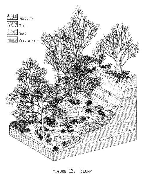
The slumps differed from debris slides in that the failure surface cut the underlying substrate, a significant quantity of which was included in the slide mass (figures 11 and 12). The position of at least part of the failure surface was controlled by certain beds within an underlying stratigraphic unit or by the contact between two such units. Slumps were generally somewhat larger than debris slides, but even the largest did not exceed a few hundred feet in maximum dimensions. The distance moved by the center of mass of slumps was usually less than approximately half the crown-to-foot length of the slide. Ten of the landslides listed in Appendix 1 began as slumps, five of which subsequently evolved into debris avalanches.
Where they occurred on slopes of sufficient steepness and height, both debris slides and slumps evolved into debris avalanches. In these slides, rapid differential internal movements resulted in an overall fluidlike motion of the slide mass. As previously mentioned, this fluidity caused Miller (1973) to call such slides earthflows; however, two important differences exist between these slides and the type of earthflow defined by Vames (1958) and referred to by Miller. As defined by Varnes (1958, plate 1), such earthflows involve "mostly plastic" material or fine-grained, non-plastic material and move at a "slow to rapid" rate (five feet per day to one foot per minute), whereas debris avalanches involve "mixed rocks, soil, clay, etc." and move at a "very rapid to extremely rapid" rate (more than one foot per minute). In both these respects the landslides referred to in this report as debris avalanches fit the definition of debris avalanches rather than that of earthflows.


All the debris avalanches originated as either debris slides (figures 13 and 14) or slumps (figures 15, 16, and 17). Debris avalanches were often elongated in the downslope direction, extending to the base of the slope or to a decrease in slope inclination. The width of the debris avalanche scar was generally proportional to the width of the originating debris slide or slump. The depth of scour by the moving debris below the foot of the landslide was quite shallow, often not even penetrating the regolith. The center of mass of the debris avalanches usually moved a distance greater than half the crown-to-foot distance, and often much further. Of the 27 debris avalanches listed in Appendix 1, 22 originated as debris slides and five originated as slumps.
Several other types of landslides described by Varnes (1958) are known to occur in Seattle but are not represented in Appendix 1. Slow earthflows, previously discussed and contrasted with debris avalanches, only rarely occur. Debris flows occasionally develop from debris slides and slumps; they differ from debris avalanches by having a higher water content and greater mobility. Soilfalls frequently occur along the sea cliffs adjacent to Puget Sound and, although usually quite small, are locally responsible for considerable cliff retreat.
Mechanisms
Over three quarters of the landslides included in Appendix 1 originated as debris slides. They may be considered infinite slope failures as analyzed by Taylor (1948, p. 418-431) inasmuch as they occur on slopes of nearly constant inclination, are shallow relative to their areal extent, and involve a fairly uniform thickness of regolith. If the soil properties do not vary areally, the stability analysis of a potential slide mass is reduced to an analysis of the stresses in a column of soil extending from the ground surface to the substrate (figure 18). The vertical stress at the base of the regolith is

W cos i = ![]() z cos i
z cos i
where W is the weight of
the column of unit width,![]() is the unit weight of the soil, z is the thickness of the regolith
(measured vertically) and i is the inclination of the slope. The
shear stress on the potential failure surface at the base of the
regolith and parallel to the slope is thus
is the unit weight of the soil, z is the thickness of the regolith
(measured vertically) and i is the inclination of the slope. The
shear stress on the potential failure surface at the base of the
regolith and parallel to the slope is thus
![]() =
= ![]() z cos i sin i
z cos i sin i
and the normal stress is
![]() =
= ![]() z cos
z cos![]() i.
i.
The shear strength at the base of the column of soil is
s = c' + (![]() - u) tan
- u) tan ![]() '
'
where c' is the effective
cohesion of the soil, ![]() '
is the effective angle of internal friction, and u is the pore water
pressure at the base of the column. As will be shown under Relationship
of landsliding to stratigraphy,
the debris slides were generally underlain by stratigraphic units of
extremely low permeability, such as the Lawton Clay and most of the
pre-Vashon sediments. This causes the movement of the groundwater
within the regolith to be approximately parallel to the surface of
the slope. The elevation of the water table above the substrate is
shown as distance h in figure 18. Under these conditions the pore
pressure at the base of the regolith is
'
is the effective angle of internal friction, and u is the pore water
pressure at the base of the column. As will be shown under Relationship
of landsliding to stratigraphy,
the debris slides were generally underlain by stratigraphic units of
extremely low permeability, such as the Lawton Clay and most of the
pre-Vashon sediments. This causes the movement of the groundwater
within the regolith to be approximately parallel to the surface of
the slope. The elevation of the water table above the substrate is
shown as distance h in figure 18. Under these conditions the pore
pressure at the base of the regolith is
u = ![]() (w)
h cos
(w)
h cos![]() i
i
where ![]() (w)
is the unit weight of water. Combining this relationship with the
previous two equations yields
(w)
is the unit weight of water. Combining this relationship with the
previous two equations yields
s = c' + ![]() z cos
z cos![]() i (1 - ((
i (1 - ((![]() (w) h)/(
(w) h)/(![]() z))) tan
z))) tan ![]() '.
'.
Failure occurs when the shear stress becomes equal to the shear strength, i.e. when
![]() z cos i sin i = c' +
z cos i sin i = c' + ![]() z cos
z cos![]() i (1 - ((
i (1 - ((![]() (w) h)/(
(w) h)/(![]() z))) tan
z))) tan ![]() '.
'.
In a study of slumps involving the Lawton Clay that occurred during the construction of Interstate 5 in Seattle, Palladino (1971, p. 82) found that, although the peak strength parameters for the Lawton Clay were
c' = 0.65 tons/ft![]() and
and ![]() '
= 35°,
'
= 35°,
the field strength of the Lawton Clay was more closely related to the residual strength parameters, which were approximately
c'(r)
= 0 and ![]() '(r)
= 15°
'(r)
= 15°
where c'(r)
and ![]() '(r)
are the residual effective cohesion and the residual angle of
internal friction, respectively.
'(r)
are the residual effective cohesion and the residual angle of
internal friction, respectively.
The lower portion of the regolith involved in the debris slides considered in this paper generally consisted of material derived from the under-lying substrate. For the regolith overlying the Lawton Clay and some of the pre-Vashon sediments, this material formed largely by the slow hydration and slaking of the silt and clay. The failure surfaces of the debris slides were usually located along the interface between the underlying, undisturbed clay and the overlying regolith. Below this interface the shearing resistance of the substrate increased to its peak strength, and above this interface the increasing density of plant roots probably caused an apparent cohesion that inhibited failure.
Assuming the above
residual strength parameters for the shearing resistance along the
interface between the substrate and the regolith, and a unit weight
of 120 pounds/ft![]() for the regolith, the previous equation reduces to
for the regolith, the previous equation reduces to
h/z = 1.925 - 7.18 tan i.
Thus the distance that the water table must rise above the substrate (expressed as a fraction of the total thickness of the regolith) in order to induce a debris slide is a function of the slope inclination (figure 19).

Figure 19 suggests that debris slides should not occur in areas sloping less than approximately 13 percent and underlain by substrate having residual strength parameters equal to or exceeding those of the Lawton Clay. This conclusion is supported by figure 20, which indicates the number of landslides occurring in various categories of slope inclination, and which will be further discussed in the next section. In the present context, however, it is useful to note that only three of the 37 landslides originating as debris slides occurred on slopes of <15 percent inclination, and that none occurred on slopes inclined <10 percent. Figure 20 also shows that a large number of debris slides occurred on slopes of >30 percent inclination, whereas figure 19 would seem to indicate that significant quantities of regolith cannot accumulate on slopes inclined more than approximately 27 percent. The accumulation of some regolith is a prerequisite for debris slides, and is explained by at least two departures from the assumptions upon which figure 19 is based. Many of the debris slides represented in figure 20 were not underlain by the Lawton Clay, but by other materials having greater residual strength. Also significant is the role of vegetation in establishing a zone of apparent cohesion that partially overlaps the underlying region of higher (peak) strength, thus allowing a finite thickness of regolith to accumulate in areas where the residual strength of the soil alone would be insufficient. The amount of apparent cohesion generated by root systems and the rate of weathering of the underlying substrate have not been investigated in this study, but might be useful subjects for future research, offering a theoretical approach to the problem of estimating recurrence intervals of debris slides.
Ten of the landslides included in Appendix 1 originated as slumps rather than as debris slides. The slumps are more difficult to describe with generalized analyses because they often involved more than one type of material, each type having its own strength parameters. Furthermore, the slumps were generally associated with ground-water conditions that were stratigraphically controlled, thus complicating the calculation of effective stresses. Generalized analyses are available for relatively simple models involving sand overlying clay or sand beds within clay (Henkel, 1967), but the application of such models requires more information about pore-water pressures than is normally available in reconnaissance work, where such models are of greatest utility. Furthermore, analyses based on seepage along certain contacts or beds appear unrealistic considering the relationships between landsliding and precipitation that are described under CLIMATIC FACTORS. The rapidity with which both slumps and debris slides responded to precipitation suggests that the slides were related to changes in pore pressures within a few feet of the surface. This, in turn, suggests that many of the slumps involved retrogressive failure triggered by debris slides or by localized failures near the contact between an overlying impermeable unit (e.g. the Esperance Sand) and an underlying impermeable unit (e.g. the Lawton Clay), where a local steepening of the water table can be expected immediately following a period of intense precipitation.
Subsequent changes in style of movement transformed 27 of the debris slides and slumps into debris avalanches. The conditions under which debris avalanches develop and continue to move are not predicted by Mohr-Coulomb failure criteria since failure has already occurred. The movement of debris avalanches is a rheological problem that has not yet been fully solved, but probably involves factors common to both debris flows (Johnson, 1970, p. 495-519) and rock fragment flows (Hsu, 1975) as defined by Varnes (1958).
GEOLOGIC FACTORS
Relationship of landsliding to topography
Slope inclination was used by Miller (1973) as one criterion for evaluating relative slope stability in an area south of Seattle. By measuring the distance between contour lines on topographic maps the area of that study (except for land extensively modified by human activities) was divided into two categories: areas sloping <15 percent and areas sloping >15 percent. Areas sloping <15 percent were considered relatively stable; areas sloping >15 percent were considered less stable and were further subdivided according to the nature of the underlying material. Selection of 15 percent as the boundary used for slope mapping was based on previous experience with landslides in the area, although figure 19 suggests that it is also justifiable on the basis of soil mechanics.
The slope inclination for each of the 47 landslides included in Appendix 1 was determined from topographic maps in a manner similar to that described above, and the results are expressed in figure 20. All but three of the landslides occurred in areas sloping >15 percent, and those three slides occurred in areas sloping >10 percent. The use of 10 percent as the boundary for slope mapping would include the latter slides but would also increase the total area outlined by approximately 50 percent (Tubbs and Frederick, 1974). Increasing the boundary value to 20 percent would exclude a total of four slides, but would not significantly decrease the area included from that outlined by the 15-percent criterion. Thus, for empirical as well as theoretical reasons, 15-percent slope appears to be a useful criterion for constructing maps of relative slope stability in the Seattle area.

Another topographic factor that might affect slope stability is the aspect of the hillside. Winter storms in Seattle generally come from the southwest, so precipitation might be greater on the southwest than on the northeast sides of hills; also, due to differences in insolation, north-facing slopes might be wetter than otherwise similar south-facing slopes. The aspects of the hillsides in the immediate vicinity of the 47 landslides included in Appendix 1 were therefore measured from topographic maps and are plotted as figure 21.

Although a large number of landslides did occur on slopes facing slightly south of west, a comparable number occurred on slopes facing the opposite direction. The symmetrical pattern reflects the fact that most hillsides in Seattle face one of these two directions, because glaciation produced hills and linear uplands that are generally aligned in a direction from slightly west of north to slightly east of south. Slopes with northern aspects experienced a somewhat larger number of landslides than did slopes with southern aspects. However, it is not clear that this difference is due to microclimatic effects, because there are more steep north-facing than south-facing slopes in Seattle.
Relationship of landsliding to stratigraphy
Slope stability in Seattle is strongly influenced by stratigraphic factors. Table 2 summarizes the stratigraphic relationships of the 47 landslides included in Appendix 1. Landslides immediately underlain by more than one stratigraphic unit (e.g. landslides occurring along stratigraphic contacts) are attributed to the stratigraphically lowest unit. Table 2 demonstrates a strong correlation between landsliding and the presence of either the Lawton Clay or pre-Vashon sediments. Although these materials together immediately underlie less than 10 percent of Seattle, they were present beneath nearly 80 percent of the landslides. This relationship is partly due to the generally very low permeability of the Lawton Clay and pre-Vashon sediments as compared to other stratigraphic units in Seattle. The presence of a relatively impermeable substrate is conducive to the development of seepage forces within the overlying material, and is an important factor affecting slope stability in the Seattle area.

Miller (1973) used the type of substrate as a criterion for evaluating slope stability in an area south of Seattle. Excepting land extensively modified by human activities, areas sloping <15 percent were considered relatively stable, areas sloping >15 percent and underlain by stratigraphic units containing "tight silt or clay" were considered relatively unstable, and areas sloping >15 percent but underlain by other materials were considered of intermediate stability. Tubbs (1974a) demonstrated that there was a good agreement between the locations of landslides known to have occurred during early 1972 and the relative slope stability as evaluated by Miller.
Table 2 also shows a strong correlation between landsliding and the presence of the contacts between the Esperance Sand and either the Lawton Clay or pre-Vashon sediments. This is primarily an effect of the contrasting permeabilities of the stratigraphic units. Where the Esperance Sand overlies the Lawton Clay the movement of ground water within the Esperance Sand is largely controlled by the uppermost laterally extensive silt and clay bed within the Lawton Clay. The trace of the contact between the Esperance Sand and the Lawton Clay is therefore typically the site of considerable seepage, which decreases the stability of the Esperance Sand in the immediate vicinity of its lower contact, and contributes to the saturation of the regolith along that contact. Similar conditions prevail where the Esperance Sand overlies pre-Vashon sediments.
A slight variation of this scheme may occur where sand is intercalated within the upper part of the Lawton Clay. Under such circumstances water may enter the sand beds at some distance from the hillside, resulting in seepage and the development of significant pore-water pressure within the sand beds. Where the Esperance Sand overlies pre-Vashon sediments this variation is not applicable; however, weathering during the Olympia Interglaciation produced clays with undesirable engineering properties that locally may contribute to instability along the contact between the Esperance Sand and pre-Vashon sediments.
The contacts between the Esperance Sand and either the Lawton Clay or pre-Vashon sediments appear to affect slope stability even where the contacts are covered by the Vashon till. Four of the seven slides underlain by Vashon till occurred at or near the inferred local elevation of one of these contacts. Water derived from the Esperance Sand behind the till appears to contribute to the saturation of the regolith in areas where the till is relatively thin. The thickness of till necessary to prevent the influence of such water has not been evaluated, but is expected to be primarily a function of the permeability of the till and the hydraulic head within the Esperance Sand.
Predictive implications
On the basis of the relationships between landsliding and the previously discussed topographic and stratigraphic factors, a slope-stability map of Seattle was constructed in the following manner. Areas mapped as artificial fill or modified land by Waldron et al. (1962) were outlined and designated modified land; these areas were excluded from slope-stability classification because their stability is largely dependent upon the design of the grading project. The traces of the contacts between the Esperance Sand and either the Lawton Clay or pre-Vashon sediments were plotted on the map, using information from Waldron et al. (1962), Liesch et al. (1963), Waldron (1967), and field data collected as part of this study. A zone representing a strip of land approximately 200 feet wide was drawn along those traces and designated class 4. This width approximates the horizontal extent of a 35-foot thick stratigraphic interval outcropping on a 15-percent slope. Thirty-five feet is the thickness of the intercalated zone within the top of the Lawton Clay at its type section (Mullineaux et al., 1965), and appears to be the maximum depth within the Lawton Clay at which sand beds are commonly involved in landsliding; it exceeds the depth of the weathered zone locally developed upon pre-Vashon sediments (Mullineaux et al., 1964). Class 4 areas are considered relatively unstable.
The remainder of the land area of the city was divided into two categories: Areas sloping <15 percent and areas sloping >15 percent. Areas sloping <15 percent (excepting areas previously designated class 4) were designated class 1, and are considered relatively stable. Areas sloping >15 percent (excepting areas previously designated class 4) were subdivided into class 2 and class 3 on the basis of the underlying substrate. Class 3 areas are directly underlain by either the Lawton Clay or pre-Vashon sediments, whereas class 2 areas are underlain by the Esperance Sand or younger stratigraphic units. Class 3 areas are considered less stable than class 2 areas; both class 2 and class 3 areas are considered intermediate in stability between class 1 and class 4 areas.

Plate I. Slope-stability map of Seattle
(Click on map to enlarge)
The resulting map is included as plate I. The capability of this map to predict the spatial distribution of landsliding and the relative hazard associated with each of the four classes indicated on the map has been assessed by comparing the locations of the landslides included in Appendix 1 to the classification of those locations as indicated on the map. In the comparison all landslides occurring on the boundary between two slope stability classes were attributed to the less stable class. As shown in table 3, progressively larger numbers of landslides occurred in progressively less stable classes. When the amount of land included within the various stability classes is considered and a comparison made of the landslide density (the number of landslides per unit area) this relationship is accentuated.

Some of the landslides are shown as having occurred in more stable classes than their topographic and stratigraphic relationships would merit, because of the scale of topographic and geologic mapping in the Seattle area. The two slides attributed to class 1 areas actually occurred on slopes of >15 percent inclination, but of insufficient height to be shown with a 25-foot contour interval. Likewise, at least two of the landslides that are shown as having occurred in class 2 areas were underlain by pre-Vashon sediments that were not indicated on existing geologic maps. Although minor adjustments to the location of contacts shown on existing maps were made on the basis of field observations, no attempt was made to totally remap the city. Despite these sources of inaccuracy the agreement between the locations of landslides and the slope-stability classes shown on plate I is excellent, with a landslide density for class 4 areas over two orders of magnitude larger than for class 1 areas.
The relationship between landslide-damage density and the slope-stability classes shown on plate I is even stronger, the difference between class 4 and class 1 areas being over three orders of magnitude. It should be noted that table 3 depicts the hazard associated with the various slope-stability classes rather than the hazard within those classes. Some of the damage attributed to the relatively unstable areas actually occurred in adjacent, more stable areas. Landslides originating within the relatively unstable areas shown on plate I can affect both upslope areas (by the retrogressive failure of slumps) and downslope areas (by the generation of debris avalanches). In using slope-stability maps to make decisions concerning landslide hazard, it is necessary to consider the possible effects of landslides originating within a relatively unstable area upon adjacent, more stable areas.


