
GEOLOGIC HAZARDS IN SEATTLE
by
Donald W. Tubbs and Thomas Dunne
A field guide for
The Geological Society of America Annual Meeting
1977
INTRODUCTION
Geologic hazards in Seattle include earthquakes, landslides, shoreline erosion and floods. Volcanic hazards are an important consideration in the Pacific Northwest but their impact on the Seattle area would be largely indirect and due to economic factors. On a state-wide basis flooding has historically caused the most damage (Ad Hoc Committee on Geologic Hazards, 1974), but it is not of primary importance in Seattle. Some urban-runoff problems do exist within the city where local watersheds (e.g. Thornton Creek) have been urbanized , however these problems are not particularly severe because of the low-intensity (albeit frequent) nature of Seattle's rainfall. Shoreline erosion is primarily of importance through its effect on slope stability and will be discussed in that context.
Landslide and seismic hazards are of greatest concern in the Seattle area. Of these, landslide problems are the more easily illustrated and are the primary subject of this field guide. Seismic hazards are more difficult to illustrate in the Puget Sound lowland than in other areas of the West Coast, partly because of the paucity of bedrock outcrops and the consequent difficulty in defining active faults. However, the Puget Sound lowland is a seismically active region and it is possible to identify areas of high ground-shaking potential.

GEOLOGIC BACKGROUND
Seattle, like most of the Puget Sound lowland, is underlain by a considerable thickness of sediment, and relatively little bedrock is exposed at the surface. Bedrock outcrops only in parts of southeastern Seattle and in the vicinity of Alki Point (Waldron and others, 1962) (Figure 1). The bedrock exposed within the city is marine, tuffaceous sandstone, siltstone and shale of the Blakeley formation and ranges in age from middle Oligocene to early Miocene (Liesch and others, 1963, p. 13).
During late Miocene time the Blakeley formation and older rocks were folded into a series of anticlines and synclines with axes trending approximately northwest-southeast (Mackin and Gary, 1965). Primarily on the basis of geophysical data, Rogers (1970) delineated several faults paralleling these trends, and also identified a second set of faults trending east-west. One such east-west structure, which Rogers called the Seattle-Bremerton fault, passes through Seattle just north of Aiki Point.
Most outcrops within Seattle, and all outcrops north of Aiki Point expose sediments of late Quaternary age. Depth to bedrock in the northern part of the city ranges from two to four thousand feet (Hall and Othberg, 1974). Sediments of earlier Quaternary and Pliocene age are probably present at depth, but such materials are not exposed in the city.
Relatively little evidence exists within Seattle for glacial and interglacial events prior to late Olympia Interglacial time; most of the earlier sediments are buried or have been destroyed by erosion. The older material is visible only in scattered outcrops from which it is difficult to interpret earlier events. Where these older sediments have been studied, one or possibly two older glaciations have been recognized (Mackin and others, 1950; Stark and Mullineaux, 1950, p. 23; Waldron, 1967). Studies elsewhere in the Puget Sound lowland have demonstrated at least four or five glaciations (the actual number depending on the correlations assumed) separated by interglaciations (Crandell and others, 1958: Easterbrook and others, 1967; Mullineaux, 1961, p. 71).
The interglaciation immediately preceding the most recent major glaciation was named the Olympia Interglaciation by Armstrong and others (1965). During the Olympia Interglaciation the Puget Sound lowland probably looked much like it does today, except perhaps for the absence of the marine inlets that presently comprise Puget Sound. Hills that were roughly 60 to 100 meters high, with steep slopes and relatively flat tops, existed in some of the same positions as Seattle's present hills; they were separated by broad valley floors where fluvial and lacustrine deposits accumulated. The hills were sites of weathering and erosion during Olympia time: a zone of montmorillonitic weathered clay has been recognized on one of these hills (Mullineaux and others, 1964), suggesting drier and possibly warmer conditions during part of Olympia Interglacial time.
Approximately 25,000 years ago alpine glaciers began to form and advance in the mountains of western Washington and an ice sheet was developing in the mountains of western British Columbia; this marks the beginning of the Fraser Glaciation (Armstrong and others, 1965). The initial phase, the Evans Creek Stade, involved the expansion of alpine glaciers in the mountains adjacent to the Puget Sound lowland. South of the latitude of Seattle the alpine glaciers did not generally reach the lowland, and further north their terminal moraines are obscured by subsequent deposits from the Cordilleran ice (Crandell, 1965, p. 346). Since alpine ice did not advance into the central Puget Sound lowland, the Evans Creek Stade is not recognized in the Seattle area. Pollen evidence, however, indicates that while the late Olympia Interglacial sediments were being deposited in the Seattle area the climate was cooler and wetter than at present (Mullineaux and others, 1965). Following the Evans Creek Stade the alpine glaciers in western Washington retreated, but the ice sheet in the mountains of western British Columbia continued to expand into the lowlands of southwestern British Columbia and northwestern Washington as the main phase of the Fraser Glaciation, the Vashon Stade (Armstrong and others, 1965).
Approximately 15,000 years ago a lobe of Cordilleran ice, the Puget Lobe, pushed south into the Puget Sound lowland far enough to block the northward-flowing drainage to the Strait of Juan de Fuca. This resulted in a large proglacial lake which drained southward into Grays Harbor via the lower Chehalis Valley. Water and sediment entered the lake from the glacier, which constituted its northern boundary, and from the highlands on both sides. The coarser sediment carried by the water was dropped as the streams entered the lake, while the silt- and clay-size particles settled to the bottom in the quieter water at some distance from the ice margin. A widespread deposit of silt and clay was thus created, which constitutes the Lawton Clay Member of the Vashon Drift (Mullineaux and others, 1965).
As the Puget Lobe advanced to the south a thick unit of proglacial fluvial and lacustrine sand was deposited. This unit, the Esperance Sand Member of the Vashon Drift, spread over the Lawton Clay and the hills of older material that protruded through the Lawton Clay. The contact between the Lawton Clay and the Esperance Sand is not generally an abrupt one; there often exists a zone, several meters thick, in which sand is intercalated with silt and clay. In describing the type section of the Lawton Clay and the Esperance Sand Members of the Vashon Drift, Mullineaux and others (1965) assigned this transition zone to the Esperance Sand Member. However, it is more expedient for mapping purpose to include the transition zone in the Lawton Clay Member. Such a reassignment is also useful in identifying certain areas of relatively low slope stability and in describing the mechanisms of the landslides. Therefore, as used in this field guide the boundary between the Lawton Clay and the Esperance Sand is informally redefined as the top of the uppermost laterally extensive silt and clay bed within the transition zone described by Mullineaux and others (1965) (Figure 2).

The Esperance Sand in some places becomes coarser and more pebbly near its top, grading into the Vashon advance outwash. In other places the Vashon advance outwash was deposited in stream channels cut into the Esperance Sand; there the change in character is more abrupt.
The front of the Puget Lobe continued to advance southward to about 100 kilometers south of Seattle; at its maximum, the ice thickness in the vicinity of Seattle probably exceeded 1000 meters. The ice scoured out the proglacial sediments more readily than the older deposits, and thus eroded troughs where there had previously been valleys and left hills with cores of older deposits (Crandell and others, 1965). Some of the material eroded by the glacier was redeposited further south as advance outwash and the remainder was incorporated into the Vashon till.
The recession of the Puget Lobe was extremely rapid. By approximately 13,500 years ago (Mullineaux and others, 1965) the ice front had retreated to a latitude north of Seattle and by 11,000 years ago the ice had retreated up the Fraser Valley. The retreating uncovered a glacially-sculptured landscape of uplands and intervening valleys. In front of the melting ice, and coursing across the uplands, were meltwater streams that connected proglacial lakes in the valleys. These streams often cut large channels and, especially where they emptied into the lakes, locally deposited Vashon recessional outwash.
A final readvance of the Fraser Glaciation, called the Sumas Stad§, occurred approximately 11,000 years ago (Armstrong and others, 1965). The ice advanced only a few miles south of the Canada-United States boundary before it again began to retreat; the Sumas Stade is not recognized in the Seattle area.
Accompanying worldwide deglaciation, sea level rose rapidly and marine water invaded the glacially carved troughs to from the inlets of Puget Sound. Most of the rise in sea level had taken place by about 7,000 years ago, but since then there has been a slow rise of relative sea level in the Puget Sound lowland amounting to about 10 meters (Biederman, 1967, p. 16).
The postglacial geologic history of the Seattle area primarily involves weathering and erosion of the uplands and infilling of the intervening valleys and inlets. The steep slopes surrounding many of the upland areas were left in a relatively unstable condition by the retreating glacier, and the instability of some slopes has been maintained or increased by shoreline erosion during the past few thousand years.
DISCOVERY PARK
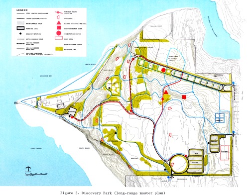
Drive to the south entrance of Discovery Park and walk down to the beach via the trail along the top of South Bluff and the road to West Point (Figure 3).
Wave erosion is the dominant marine process acting on the shoreline of Discovery Park. In the vicinity of West Point the greatest fetches occur for waves approaching from either north or the south, but the dominant wind direction is approximately southerly, especially for the higher-velocity winter winds. This has resulted in much more erosion along South Beach than along North Beach, as illustrated by the representative surface profiles across the two beaches shown in Figure 4. It appears that South Bluff has retreated more than 3 times as far as has North Bluff. Volumetrically, South Bluff has lost approximately 60,000 cubic meters of material per meter of shoreline, while North Bluff has lost only about 10,000 cubic meters per meter. By steepening the original slopes and removing material which would otherwise accumulate at the base of the sea cliffs, wave erosion has promoted landsliding along the bluffs adjacent to Puget Sound.

Walk south along South Beach, noting the relationship between the stratigraphic units exposed in the sea cliff and the types of landslides that have occurred.
The northernmost segment of South Bluff exposes Olympia Interglacial sediments overlain by Vashon till. Soilfalls (Figure 5) are the dominant mode of failure in this material where it is being actively undercut by wave erosion. Where similar material is not being undercut by waves, such as in the area east of the METRO plant, the slopes tend to recline to a lesser inclination and the landslides which occur are generally debris slides (Figure 6). Where they occur on slopes of sufficient steepness and height, the debris slides frequently develop into debris avalanches (Figure 7).


Further south along the beach, but still north of the small promontory, the Lawton Clay is exposed near the top of the sea cliff. The contact between the Lawton Clay and the underlying sediments is about a meter or two above a conspicuous line of vegetation. As evidenced by the debris which is usually present at the base of the slope, the Lawton Clay also tends to fail as sollfalls when undercut, but it characteristically fails as debris slides on gentler slopes (Tubbs, 1975).
Landsliding is most impressively displayed along the southern segment of South Bluff. Sea cliff retreat in this area was probably mainly by soilfalls until the contact between the Esperance Sand and the Lawton Clay became exposed in the cliff face. The style of landsliding then changed and the rates greatly increased. Most of the landsliding along the central and southern segments of South Bluff is now associated with the trace of the Esperance Sand-Lawton Clay contact. The reason for this association is the effect of the contact upon the movement of ground water.
Ground water percolates downward through the Esperance Sand until it meets the uppermost laterally-extensive silt and clay bed within the Lawton Clay. At that horizon it is diverted laterally to where it intersects a hillside. Along the trace of the Esperance Sand-Lawton Clay contact there is much seepage which causes the overlying Esperance Sand to fail by slumping. This process causes rapid retreat of the upper bluff and eventually creates a bench at the elevation of the contact. Blocks of slumped material accumulate on this bench and eventually move down the face of the lower cliff as debris avalanches and mudflows (Figure 8).
The upper part of the Lawton Clay includes intercalated sand layers, and in some places slumping has occurred along certain of the sand beds instead of at the top of the uppermost impermeable bed. This is usually due to the development of pore water pressure within the sand beds, and implies that the water has access to the sand beds at some distance from the bluff.
Along the southernmost segment of South Bluff no lower cliff is present and landslide debris from the upper cliff moves to the beach across a large and complex slump (Figure 9). Landslides involving large blocks of the Lawton Clay are rare, but is clearly shown here by the contorted beds of silt and clay which are exposed on the beach. Movement continues as the material rising at the beach face is removed by wave erosion. Slump blocks of Esperance Sand progressively disintegrate as they move across the failed Lawton Clay, and changes in the size and position of these blocks are visible from year to year.

PERKINS LANE WEST
Proceed to the sandy outcrop on the east side of Magnolia Boulevard W. between W. Armour Street and W. Raye Street. The outcrop is mostly Esperance Sand and Vashon advance outwash, although the upper meter or so (usually obscured by vegetation) consists of Vashon till. Cross-bedding within the Esperance Sand is variable in orientation but, especially in the lower part of the outcrop, generally indicates deposition by southward-flowing streams. The upper part of the sand is coarser, and in one area sand and gravel are visible in a channel scoured into the sand; this upward coarsening presumably reflects the southward advance of the Puget Lobe.
Walk south along Magnolia Blvd. to W. Glenmont Lane (about three blocks) and descend the stairs on the west side of the street. About a third of the way down, notice the material just north of the stairway. The upward coarsening of the Vashon advance outwash is again visible and pebbles within the gravel beds indicate a northern provenience. The upper meter of so of this outcrop (up by the madrona tree) is Vashon till; a closer look at the till will be possible later in the field trip.
While descending the stairs to Perkins Lane W., watch for the signs of the contact between the Esperance Sand and the Lawton Clay. The contact is generally covered by vegetation and slope debris, but the slope becomes noticeably wetter near the base of the stairs.
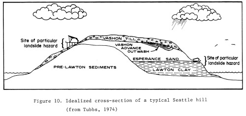
Walk north along Perkins Lane W. to W. Raye Street, where the Lawton Clay outcrops on the corner. The Lawton Clay here is a fairly homogeneous silt, but in many other places is composed of alternating layers of silt and clay and displays its bedding more clearly. Regardless of whether the Lawton Clay is composed of silt or clay, its permeability is markedly lower than that of the overlying Esperance Sand. Ground water moving downward through the Esperance Sand is diverted laterally by the top of the Lawton Clay until it reaches a hillside. There it contributes to the saturation and instability of the Esperance Sand and local slope debris. Where the Esperance Sand directly overlies impermeable pre-Lawton sediments, seepage and landslides are also common (Figure 10).
Along the bluff south of West Point the contact between the Esperance Sand and the Lawton Clay is about 25 meters above sea level. There is a more or less continuous bench along the contact due to the removal of upslope material by landsliding. Perkins Lane W. was built along this bench, and both the street and most of the houses along it are built upon landslide debris. It seems ironic that the process which created the bench, and hence made the area appear suitable for development, now plagues the property owners.
Walk south along Perkins Lane W. watching for evidence of the Lawton Clay, either in the form of outcrops or springs. Note the kinds of plants that seem to thrive in wet areas: horsetails, blackberry vines, and nettles. Such vegetation is typical of most landslide-prone areas in Seattle, Observe the hummoeky topography and the non-standard orientation of many of the trees uphill from the road; minor slides occur in this area almost every year, but they are soon obscured by the vegetation. You should also watch for effects of instability such as leaning utility poles cracks in foundations, patched pavement, buildings which are not plumb, and odd smells that might be due to broken sewer lines.
The low retaining wall along Perkins Lane W. is intended only to protect the road from blockage by minor .slides. Note the drainage holes at the base of the wall, which discharge the water that seeps into the rubble and gravel backfill behind the wall. This water is collected by storm drains and carried to the beach to insure that it does not flow across the road and contribute to problems there. However, some water seeps under the road through the landslide debris upon which the road is built.
Peer over the fence across from 2400 Perkins Lane W. In 1968 a slide occurred at this site which destroyed part of the road. To protect the road the city bought the downhill property, built a breakwater, and placed a massive fill behind it. The fill includes an extensive drainage system and water can normally be seen exiting from one of the drains at the northwest corner of the fill. The project cost the city about $75,000.
Observe the general condition of the house at 2315 Perkins Lane. (Important: the owner of this property has had some unfortunate experiences with the public, and asks that you do not trespass. Please honor his request. An adequate view can be obtained from the should of the road on the south side of the house.) This house was originally on the other side of the road, where there is now a small turn-around. About twenty years ago it slid into the street, and was then moved to approximately its present position. At that time the original house was remodeled and expanded in size. Unfortunately, its new foundations were footed in slope debris resting on the Lawton Clay, and about ten years ago it slid again. The broken concrete foundation may still be visible beneath the house. The present owner has attempted to salvage the house by putting new footings down to the clay (rather than merely into the remaining debris) and by installing a system of drains so that the surrounding material does not move.
A few steps to the south an exposure of Esperance Sand is visible about 10 meters above the road. Slightly further south it is sometimes possible to see an exposure of Lawton Clay near road level (when it isn't hidden by the horsetails) . Across from 1967 Perkins Lane is another outcrop of Esperance Sand but the inclination of the bedding indicates that this outcrop is part of a large slump block.
Just north of the stairs at Montavista PI. W. a slide occurred in 1974 while the city was installing the retaining wall. Such slides were not uncommon when cutting into the bank and therefore the larger trees, which might damage houses or utility wires across the street if they fell, were often removed before construction of the retaining wall.
If it has been raining during this field trip, the less sure-footed may wish to note the presence of the stairway here. This field trip will soon take a route that the neighborhood kids call the "goat trail." If you don't feel like a goat, you can double back to this point and ascend the stairs.
The slippage of the road shoulder just south of 1925 Perkins Lane began in 1974. The main slide however, at the south end of the wooden fence, occurred in 1972. The Esperance Sand is not well exposed here because it is mostly covered by the Vashon till. In the lower part of the slide scar (not visible from the road) the Lawton Clay is exposed and includes a few interbeds of sand. High pore-water pressure in these interbeds may have played a large role in causing the slide. To stabilize this landslide in the manner utilized near 2400 Perkins Lane would cost about $170,000; the city has been considering alternative measures since 1972. The plastic covering and the pumping station across the street are intended to help keep things stable until more permanent measures are taken. There are only five houses beyond this stretch of road. While these houses together are certainly worth more than $170,000 (property along Perkins Lane W. is not cheap, despite the landslide hazard) there is no assurance that there will not be other slides elsewhere along this stretch to contend with in the future. Indeed, other landslides have already occurred and they will continue.
Walk down the road 50 meters or so beyond the "Dead End" sign, past a small slide that occurred in 1974, and take the "goat trail" up the hill. En route it is possible to get a close look at the Vashon till. Note the fissility and the horizontal orientation of many of the tabular pebbles. Although more difficult to see, there is also a preferred north-south orientation to the elongate pebbles. (Vashon till is also visible near the top of the stairs at Montavista PI. W., if you chose that route. However, the exposure is not as good.)
From Magnolia Park at the top of the trail, one obtains excellent views of Puget Sound (on a clear day). West Seattle lies to the south, with Duwamish Head at its north end and Aiki Point on its west side. During 1974 a two-block-long segment of the hillside between Duwamish Head and Aiki Point was the site of extensive landsliding which damaged about a dozen houses. The Esperance Sand-Lawton Clay contact is located along the bench just above the barely visible slide scar. The geologic conditions that occur along Perkins Lane W. are present there, and also in several other parts of the city, with similar consequences.
WEST SEATTLE
Alki Avenue S.W.
Take Interstate 5 to the West Seattle Freeway and drive west to the Harbor Avenue exit. Head north on Harbor Avenue S.W. to Duwamish Head where it becomse Alki Avenue S.W., and follow Alki Avenue S.W. to the 1500 block.
The association between stratigraphy and landsliding along Alki Avenue S.W. is generally the same as that at Discovery Park and Perkins Lane W. The hazard to structures, however, occurs mainly at the top and bottom of the section rather than only on the central landslide bench. Several years ago residential development was planned for a part of the bench and some utilities were installed before building permits were withheld.
The general problem is best observed from the seawall opposite the 1500 block of Alki Avenue S.W. (Figure 11). Slumping of Esperance Sand at the top of the upper cliff is undermining the street and threatening houses. Slump blocks move slowly across the wooded landslide bench, disintegrating into the 1-3 meter thick layer of structureless light gray material visible at the top of the lower cliff. At times during wet weather landslide debris and trees fall over the lower cliff onto the houses below (Figure 12). A failure during early 1974 stripped nearly all vegetation from a 150 meter long section of the cliff.

The Lawton Clay can here be separated into two phases. Below approximately 15-17 meters above road level it includes clayey silt, silt and fine sand. Drill holes into this lower sandy phase indicate that it is not saturated with ground water. The clayey phase above that elevation is hard and extremely impermeable. It varies from massive to finely laminated clayey silt and contains numerous fracture surfaces along joints and bedding planes; some of the joint surfaces exhibit slickensides. The disturbed upper surface of the clay slopes 5-10° to the northwest (outward from the cliff) and has some irregularities. Some of the joints and irregularities localize ground water which emerges from below the landslide debris as springs.
The intercalated layers of silt and sand at the top of the Lawton Clay here form a 5 meter thick transition zone at an elevation immediately above the base of the landslide in the front of the lower cliff. The permeability and shear strength of this zone are highly variable. The Esperance Sand here is a 25 meter thick layer of dense, fine to medium sand having high permeability.
California Way S.W.
From the cliff on Alki Avenue S.W. drive northeast (toward downtown Seattle),then southeast on Harbor Avenue S.W. and make a sharp right turn onto California Way S.W. About 125 meters beyond the turn, on the east side of the road, is a steep hillside with young vegetation and obvious signs of recent soil disturbance. The hillslope has been the site of repeated landsliding during the past few years. The most recent failures occurred in the winter of 1974 when two landslides, each of several hundred cubic meters, blocked the roadway. One of them crossed the road as a mudflow and damaged a house at the foot of the slope where the condominium is now being built. It left mud 2 meters above the sidewalk on the telephone pole west of the road.
The stratigraphy and pattern of landsliding at the site are sketched in Figure 13, which is based on borehole information and interpretations by Shannon and Wilson, Inc. (1975). Several small and slightly arcuate scarps run roughly parallel to the contours. Seepage occurs below each scarp and several of the largest seeps emerge from the lowest recent failure site. A narrow bench interrupts the generally smooth hillslope profile 10 meters higher than the road. This feature indicates the upper limit of the dense, impermeable zone of the Lawton Clay. On the bench rests a thin layer of landslide debris which has collapsed from the steeper hillside facet upslope. The cause of these shallow failures appears to be undermining of the toe of the slope by ground water that emerges from the Esperance Sand and from sandy layers in the transition zone. Individual slump blocks within the Esperance Sand here are smaller than those seen at Discovery Park. Copious amounts of water flow out of the hillside at this level during wet weather. The estimated position of the water table in Figure 13 is drawn on the basis of water-level measurements in boreholes during March of 1975 (Shannon and Wilson, Inc. 1975).
During wet weather the failed material on the bench becomes wet enough and thick enough to move as shallow slides and mudflows which frequently reach and cross California Way S.W. The road itself is built upon loose material which contains blocks of clay in a sandy matrix and is probably landslide debris at least in part. The pavement and sidewalk show evidence of settling. The Lawton Clay softens rapidly when exposed to weathering and its weakened surface has been eroded by water and mudflows into the present rounded form (see Figure 13). The Lawton Clay does not appear to be failing by landslide processes here.

Sunset Avenue S.W.
Follow California Way S.W. up the hill and around a sharp bend to the left. Three blocks beyond the bend turn right onto S.W. Seattle Street and drive four blocks to its junction with Sunset Avenue S.W. On the western side of Sunset Avenue S.W. a guardrail and traffic barrier is adjacent to the top of a slump involving Esperance Sand. Failure is occurring along steep, arcuate surfaces and the failed blocks characteristically rotate slightly during an initial movement of 3-5 meters. The hillslope has an angle of about 40° in consolidated sand having an angle of internal friction of approximately 35 . Even in the record dry winter of 1976--77 one small slump occurred.
The sidewalk has been completely destroyed within the past five years and recent concrete work is already beginning to show signs of movement. The sewer line has been recently relocated to the opposite side of the street and the pavement has been patched. The street and at least two houses are in danger of serious damage within the next decade unless the bluff can be stabilized during that time.
From the top of the bluff one has a better view of the landslide bench first seen from Aiki Avenue S.W. Its surface slopes irregularly away from the bluff. At first glance it appears to be stable: trees are upright, the gradients are not excessive and there are no obvious scars. However, the bench is the site of slow, intermittent land-sliding, signs of which are best seen from the trails shown in Figure 14.

Walk one block west along Sunset Avenue to S.W. Massachusetts Street; turn right and then follow the narrow lane known as Bonair Drive S.W. downhill to the remains of a stone gateway on the right. Pass through the gateway and follow the trail to the right. The trail crosses the irregular surface underlain by blocks of Esperance Sand which have slumped from the upper bluff. The blocks form a set of small horsts and grabens, between which cracks open during wet winters. Notice the closed depressions, reversed slopes, cracks and escarpments. The relief between adjacent blocks ranges up to 8 meters.
The pattern of movement in early 1974 is shown by the heaviest dashed lines in Figure 14 which indicate the major scarps which formed at that time. The fresh faces exposed by the 1974 movements were up to 1.5 meters in height. Figure 14 also shows the distribution and direction of movement of older scarps.

The general style of movement can be visualized by examining Figures 14 and 15 and the topography of the bench. The slump blocks are moving away from the upper bluff toward the lower cliff. The exact location of the failure surface is unknown. Subsoil properties in boreholes indicate that the thickness of the slide material varies from about 20 meters at the base of the upper cliff to 1-3 meters at the top of the lower cliff (Shannon and Wilson, 1975). Movement is triggered and accelerated by high porewater pressure which reduces the effective shear strength. The origin of the ground water is rain water that infiltrates the glacial till and sand. In parts of the bench the water levels in boreholes lie close to the ground surface (Shannon and Wilson, 1975). Ground-water flow appears to be concentrated toward certain locations, such as the gullies in the northern part of the bench shown in Figure 14, and the section of the bench which is the focus of most of the movements shown in the figure.
The pattern of open cracks and of slump blocks migration across the bench indicates that the movements are generally extensional. It appears that the material on the bench is sliding intermittently on a surface having an average angle of 8-10 (Figure 15). Such failure is appropriate for fully saturated cohesionless materials on a surface along which the angle of effective internal friction is close to 15°. Palladino (1971) reported that the residual shear strength values for the Lawton Clay are: effective cohesion = 0; effective frictional angle = 13.5 - 17.5 . It is not certain from field observation, however, whether the failure surface is within the clayey phase of the Lawton Clay or within the transition zone of intercalated silts and sands. The migration of slump blocks on this low-angle failure surface removes support from more recently failed material at the base of the upper cliff, causing failure and headward retreat of the cliff.
Walk along the dead-end trail that leads northwest to near the intersection of the lower cliff and the largest gully in Figure 14. In the face of the cliff and the edges of the gully there is an outcrop of the light gray, sandy landslide debris which varies in thickness from 1-3 meters. Beneath this mobile layer the clayey phase of the Lawton Clay can be seen in place in the lower cliff. It is recognizable by its gray color and by a narrow line of vegetation along the upper margin of the clay where water emerges during wet periods.
Notice that some of the roofs below are new or recently patched. They were damaged by trees carried over the cliff by landslide debris in early 1974 (see Figure 12).
Walk back to the main trail, turn southwest and follow the right fork towards the edge of the lower cliff. Notice the fresh scarps bounding slump blocks along the edge of the trail and through the trees on your left. Seventy meters from the fork, follow a minor path between blackberry bushes to the edge of the cliff. Walk carefully because the soil near the cliff is highly unstable during wet weather.
Although it has been recolonized by alders and other plants, the cliff in this vicinity shows signs of vigorous, shallow mass wasting. Debris that is more fluid than the debris observed at the last site occasionally flows down the scarp, damaging fences and houses at the base. During early 1974 these flows were large enough to strip all vegetation from the scarp and to inundate the backyards and parts of the buildings. A stream of mud reached the roadway through the wide grassed alley between two houses. Since that time a few small mudflows have occurred and the nature of the material at the overlook point assures that such mudflows will continue to occur.
Most failures in Seattle do not move very far from their point of origin. The water content of most geologic materials in the city are below the liquid limit of failure. The liquid limit of Lawton Clay, for example, varies from 23 to 65 (mean of 47), and natural water content varies from 12 to 48 (mean of 31) according to Palladino (1971). At a few localities, usually in the upper Lawton transition zone, the water content is high enough to allow flowage after the initial failure. The top of the lower cliff at the south-eastern section of the bench shown in Figure 14 appears to be such a locality. The concentration of water is suggested by the pattern of scarps, by the emergence of several springs from the landslide debris at the edge of the cliff and by the high water content of debris at the edge of the cliff. This material can be made to flow by vibrating it rapidly, but this procedure is not recommended too close to the edge of the cliff for obvious reasons.
Walk back along the path to the trail and follow it back to the stone gateway. It traverses several large slump blocks with conspicuously fresh scarps. As you approach the gateway you will notice, on the right of the trail, electrical cables that were installed several years ago for residential development. Two other such installations are located on the eastern and northeastern sections of the loop trail that you have followed. The building permit was withdrawn before further development could take place. Elsewhere in the city, however, the hazard on the landslide bench was recognized too late and construction was completed. Expensive engineering projects were undertaken, including drainage and regrading, but problems have continued during the few years since construction.
Follow Bonair Drive S.W. down the hill toward Aiki Avenue S.W. Just before reaching the base of the slope the road crosses the head of another landslide that occurred in early 1974. The material which moved at that time was the deposit of an ancient landslide upon which several houses and this section of Bonair Drive S.W. had been constructed. The renewed movement did not take place during a period of particularly heavy rainfall, but it did occur while an excavation was being made at the toe of the old landslide deposit (Figure 16). The resulting landslide destroyed one house, severely damaged a second house (which has since been moved to another site), and closed Bonair Drive for several years (Figure 17). The solution involved loading the toe of the landslide (note the raised parking lot behind the condominium) and the construction of a retaining wall to support Bonair Drive S.W.

From Bonair Drive S.W., turn west onto Aiki Avenue S.W. and follow it around Alkl Point to where it becomes Beach Drive S.W. Aiki Point consists of raised beach deposits which rest upon a wave-cut bedrock surface. At low tide outcrops of the Blakeley formation can be seen on the beach just south of Aiki Point (Figure 18). The bedrock is folded and dips steeply northward toward the structure that Rogers (1970) called the Seattle-Bremerton fault. Hall and Othberg (1974) have shown that depth to bedrock increases rapidly to the north of Aiki Point.

Drive east on Beach Drive S.W. to 63rd Avenue S.W., turn north, and then east onto S.W. Admiral Way. Follow S.W. Admiral Way to where it begins to descend the east side of West Seattle hill and turn into the viewpoint on the east side of the street.
The West Seattle area suffered some of the heaviest damage during the 1965, magnitude 6.5 earthquake. Mullineaux and others (1967) studied building damage in West Seattle immediately after the earthquake and found no relationship between the pattern of damage and the type of underlying Pleistocene sediment (Figure 19). The observed pattern may be related to the configuration of the bedrock beneath the sediments.

The only other part of Seattle that experienced severe damage during the 1965 earthquake was the Duwamish Valley area north of about the West Seattle Freeway. Mullineaux and others (1967) found that areas underlain by postglacial deposits and artificial fill were heavily damaged by ground shaking and subsidence, and that the Duwamish Valley suffered particularly severe damage.
To return to Interstate 5 drive south on S.W. Admiral Way and take the West Seattle Freeway. While descending the east side of West Seattle hill watch for recent landslide scars and other signs of instability. The 1965 earthquake triggered a slump in this area (Algermissen and Harding, 1965). Landslides in Seattle are closely related to rainfall (Tubbs, 1975), but neither of the two most recent large earthquakes in Seattle (1949 and 1965) occurred during particularly wet periods. If such an earthquake occurred during wet weather more damage would occur.
REFERENCES CITED
Ad Hoc Committee on Geologic Hazards, 1974, Meeting The Geologic Hazard Challenge; Report to the Washington State Legislature.
Algermissen, S. T., and Harding, S. T., 1965, The Puget Sound, Washington, earthquake of April 29, 1965: U. S. Coast and Geod. Survey Prelim. Seismol. Rept., 26 p.
Armstrong, J. E., Crandell, D. R., Easterbrook, D. J., and Noble, J. B., 1965, Late Pleistocene stratigraphy and chronology in southwestern British Columbia and northwestern Washington: Geol. Soc. America Bull., v. 76, p. 321-330.
Biederman, D. D., 1967, Recent sea-level change in the Pacific Northwest: Masters research paper, Univ. Washington, 24 p.
Crandell, D. R., 1965, The glacial history of western Washington and Oregon, in The Quaternary of the United States: Princeton, N. J., Princeton Univ. Press, 1965, p. 341-353.
Crandell, D. R., Mullineaux, D. R., and Waldron, H. H., 1958, Pleistocene sequence in southeastern part of the Puget Sound lowland, Washington: Amer. Jour. Sci., v. 256, p. 384-397.
_____, 1965, Age and origin of the Puget Sound trough in western Washington: U.S. Geol. Survey Prof. Paper 525-B, p. B132-B136.
Easterbrook, D. J., Crandell, D. R., and Leopold, E. B., 1967, Pre-Olympia Pleistocene stratigraphy and chronology in the central Puget Lowland, Washington: Geol. Soc. America Bull., v. 78, p. 13-20.
Hall, J. B., and Othberg, K. L., 1974, Thickness of unconsolidated sediments, Puget Lowland, Washington: Wash. State Div. Geology and Earth Resources Geologic Map GM-12.
Liesch, B. A., Price, C. E., and Walters, K. L., 1963, Geology and ground-water resources of northwestern King County, Washington: Wash. Div. Water Resources Water Supply Bull. 20, 241 p.
Mackin, J. H., and Gary, A. S., 1965, Origin of Cascade Landscapes: Wash. Div.of Geol. and Earth Resources Information Circular 41, 35 p.
Mackin, J. H., Mullineaux, D. R., and Stark, W. J., 1950, Glacial geology of Seattle: Univ. of Washington, The Trend in Engineering, v. 2, no. 4, p. 19-21.
Mullineaux, D. R., 1961, Geology of the Renton, Auburn, and Black Diamond quadrangles, Washington: Ph.D. thesis, Univ. Washington, 202 p.
Mullineaux, D. R., Bonilla, M. G., and Schlocker, Julius, 1967, Relation of building damage to geology in Seattle, Washington, during the April 1965 earthquake: U.S. Geol. Survey Prof. Paper 575-D, p. D183-D191.
Mullineaux, D. R., Nichols, T. C., and Speirer, R. A., 1964, A zone of montmorillonitic weathered clay in Pleistocene deposits at Seattle, Washington: U.S. Geol. Survey Prof. Paper 501-D, p. D99-D103.
Mullineaux, D. R., Waldron, H. H., and Rubin, Meyer, 1965, Stratigraphy and chronology of late interglacial and early Vashon glacial time in the Seattle area, Washington: U.S. Geol. Survey Bull. 1194-0, 10 p.
Palladino, D. J., 1971, Slope failures in an over-consolidated clay, Seattle, Washington: Ph.D. thesis, Univ. Illinois, 188 p.
Rogers, W. P., 1970, A geological and geophysical study of the central Puget Sound lowland: Ph.D. thesis, Univ. Washington, 123 p.
Shannon and Wilson, Inc. (1975) Soil investigations and stabilization measures for Aiki Avenue S.W. landslide and California Way S.W. landslide; Report to the City Engineer, Department of Engineering, City of Seattle.
Stark, W. J., and Mullineaux, D. R., 1950, The glacial geology of the city of Seattle: M.S. thesis, Univ. Washington, 87 p.
Tubbs, D. W., 1974, Landslides in Seattle: Wash. Div. of Geol. and Earth Resources Information Circular 52, 15 p.
_____, 1975, Causes, mechanisms and prediction of landsliding in Seattle: Ph.D. thesis, Univ. Washington, 88 p.
Tubbs, D. W., Dunne, T., and Sternberg, R. W., 1974, Earth sciences component, in Discovery Park Inventory and Natural History Report: Univ. of Washington Institute for Environmental Studies, p. 15-46.
Varnes, D. J., 1958, Landslide types and processes, chap. 3 of Landslides and engineering practice: Natl. Research Council, Highway Research Board Spec. Report 29, p. 20-47.
Waldron, H. H., 1967, Geologic map of the Duwamish Head quadrangle. King and Kitsap Counties, Washington: U.S. Geol. Survey Geol. Quad. Map GQ-706.
Waldron, H. H., Liesch, B. A., Mullineaux, D. R., and Crandell, D. R., 1962, Preliminary geologic map of Seattle and vicinity, Washington: U.S. Geol. Survey Misc. Geol. Inv. Map 1-354.