PROCEEDINGS FROM THE CONFERENCE
SALMON-SPAWNING GRAVEL:
A RENEWABLE RESOURCE IN THE PACIFIC NORTHWEST?
Conference Held: October 6 - 7, 1980
Seattle, Washington
GEOLOGIC AND GEOMORPHIC IMPLICATIONS FOR GRAVEL SUPPLY
By
Thomas Dunne, William E. Dietrich, Neil F. Humphrey
and Donald W. Tubbs
ABSTRACT
There are important disparities between regions of western Washington regarding the volume and quality of gravel resources. The three major types of resource: Pleistocene meltwater deposits; recent alluvial deposits; and river channel bars, differ in their location, texture and sorting, extractable volume, and the environmental consequences of their exploitation. Evaluation of the first two types of resource requires the use of established geologic procedures for mapping, sampling, and textural and lithologic analysis. Decisions on whether to exploit river channel bars should be based in part of knowledge of availability of the first two resources. Channel bars constitute a renewable resource that can be harvested along some reaches without disrupting the channel morphology. However, the chance that careless harvesting will damage fish habitat, esthetic values, or channel stability is sufficiently great that considerable forethought and careful operation are necessary. We have proposed four steps be taken before a gravel mining permit is granted: (1) define the historical activity of the river at proposed site; (2) estimate bedload transport rate through reach; (3) evaluate probable impact of bar scalping on channel stability; and (4) require explicit information on proposed mining procedure.
KEYWORDS: Gravel mining, channel stability, gravel supply.
STATEMENT OF THE PROBLEM
Useful resources of sand and gravel are widespread, but in some
places they are of small volume and are replenished slowly or not at
all. The prodigious demands of modern industrial and residential
construction frequently overtax the supply. In Japan, for example,
the sand and gravel has been entirely removed from many river
channels (1) and supplies must be imported from Taiwan. Even in less
extreme situations, the excavation of sand and gravel may conflict
with other resource values such as fisheries, esthetic and
recreational values, or with the need for stable river channels in
areas prone to flooding and channel shifting.
In the Pacific Northwest there are important regional differences in the availability and quality of sand and gravel and in the types of sources from which these materials can be obtained. This conference is particularly concerned with gravel in stream channels, but the pressure for harvesting construction materials from channels and the potential for reducing this pressure need to be discussed in the broader context of the various sources of sand and gravel (including rivers) and of the processes by which sand and gravel become available for harvesting within channels. In this paper we review the geologic and geomorphic constraints on the supply of sand and gravel in river channels and in alternative sources. We consider the possibility of estimating the quantity of the resource, and suggest some investigations that need to be directed toward this end. We also review the geomorphic consequences of exploiting each type of source.
IMPORTANT CHARACTERISTICS OF A GRAVEL RESOURCE
The location and accessibility of sand and gravel supplies
determine the feasibility and cost of transport to the site of
consumption. Thus, many deposits may be unused because they lie in
valleys of the Cascade Range and Olympic Mountains, too distant from
construction sites or roads. In some cases a trade-off may be
necessary between the high cost of transport from distant sources and
the environmental disturbance that may result from gravel operations
at more accessible locations. At present, more than three quarters of
the sand and gravel used in King County is produced in the western
half of the county. Many of these sources will soon be exhausted, and
others have already been rendered inaccessible by past and present urbanization.
The harvestable volume is another important resource
characteristic but a distinction must be made between the total
volume and the replenishment rate. In some rivers, large gravel bars
may simply indicate long-term deposition rather than a rapid supply
rate. If they are used for intensive extraction the bars will
diminish, and channel realignment or other untoward consequences may
result. In these cases it is necessary to assess the replenishment
rate and the abstraction rate that will not disrupt the site or the
channel downstream. Ancient terrace deposits may be very large but
are not replenished at all. The constraint here may be the volume
that can be mined without increasing the chance of stream-channel
diversion, alteration of groundwater flow, or esthetic degradation.
Size distribution strongly affects the usefulness of a gravel
resource. If the material is to be used tor concrete, a wide range of
size mixtures can be specified and often must be mixed to order, but
the two most commonly-used size ranges are: "fine aggregate"
containing particles between 1/50-inch (size 40 sieve) and 1/4-inch
(size 4 sieve), and "coarse aggregate" composed mainly of
gravel between 1/4-inch and 1 and 1/2-inch. Silt (smaller than a size
200 sieve) and particles larger than about 1 and 1/2 inches are
usually removed by grading the natural mixture. The latter may be
reduced by crushing which increases the cost of exploitation.
Coatings of fine sediment, oxides, or organic materials are
particularly deleterious for concrete manufacture. Standards for
artificial fills are less stringent but require a minimum of silt
(usually less than about 5 percent) and an absence of organic
material in order to assure high permeability and density of the
fill. For surfacing rural roads, especially the extensive logging
roads of the Pacific Northwest, a mixture of hard gravel and coarse
sand is desirable but often impossible to obtain because of the cost
of transportation over large distances in mountainous terrain.
A useful sand and gravel deposit should also be free of lenses of
fine sediment. If fine-grained layers occur as an overburden, as in
most of the lower Green and Stillaguamish valleys, removal increases
the cost of exploitation and usually precludes mining if the
overburden depth exceeds about 20 feet. However, if the overburden
consists of sand, it may be mixed with the gravel according to
specification for aggregate.
Finally, the lithologic and mineraloqic properties of gravel are
important constraints upon use, for they determine the durability of
the gravel against crushing and weathering. In western Washington,
granite, diorites, gabbros, quartzites, andesites and some basalts
are the most durable lithologies found as gravel, while the weakest
rocks include slightly indurated sediments derived from volcanic
rocks, easily cleaved schists and phyllites, mudstones, and some
intensely weathered basalts. The use of mechanically weak rock on
logging roads in areas such as the Olympic Mountains may be
particularly deleterious to fisheries. In that region the most
durable sandstone and siltstone gravel is found in major stream
channels. When spread onto logging roads this gravel lasts for one to
several years, depending on the intensity of traffic. The rapid rate
of breakdown requires frequent harvesting of gravel from streambeds,
and erosion of the products of the breakdown yields fine sand and
silt which infiltrate streambed gravels and reduce the spawning
success of anadromous fish (Cederholm, this volume).
Some rock types are unsuitable for concrete because they react with mortar. Andesite, which constitutes from 10 to 30 percent of gravel in deltas of King County and is common in river valleys draining the Cascade volcanoes, reacts with alkali mortar and expands (2). The rock minerals should be relatively resistant to weathering so that they do not release sulfides or iron oxides. Thus glassy rocks and those containing cryptocrystalline minerals are not suitable. A significant proportion of the sand and gravel in the White River valley and in other valleys draining the recently active Cascade volcanoes is less than ideal for concrete aggregate for these lithologic reasons.
GEOLOGIC BACKGROUND OF GRAVEL SUPPLY
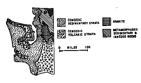
The distribution of desirable sand and gravel in western Washington is determined by the major geologic subdivisions of the area and by the extent of glaciation'(2). Figure 1 is a generalized map of the major types of lithology to be considered.
Figure 1. Generalized geolgical map of western Washington. Source: McKee (15).
As the most recent glacier entered the Puget Sound lowland it probably encountered terrain similar to the present one, with uplands and river valleys. The ice advance blocked the northward drainage to the Strait of Juan de Fuca, forming a large lake in the central portion of the Puget Sound lowland. Streams draining into this lake from the ice sheet and from the mountains to the east and west produced widespread deposits of silt and sand; however, much of this material was subsequently either scoured out by the advancing ice or covered with glacial till: a non-sorted, non-stratified mixture of sand, silt, and clay deposited beneath the glacial ice.
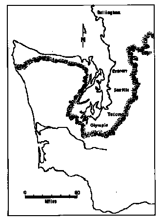
Figure 2. Extent of Fraser glaciation. Source: McKee (15).
As the ice withdrew, it uncovered a glacially-sculpted landscape of
uplands and intervening valleys. Because the ice still blocked the
northward drainage of the Puget Sound lowland, the valleys were again
occupied by lakes. It was during the retreat of the glacial ice that
most of western Washington's sand and gravel were deposited. The
deposits generally originated in one of three forms: as meltwater
channel deposits which were left behind by the glacial outwash
streams that coursed across the uplands, as kame deposits
which were left behind by streams flowing between the remaining ice
and the adjacent valley walls, and as glacial outwash deltas
that were deposited where the meltwater streams entered the
proglacial lakes. Of these three types of deposits, the glacial
outwash deltas are the most important gravel resource because of
their volume and composition of well-sorted, clean gravels with only
minor silty lenses. Meltwater channel deposits have poorer sorting
and frequently contain deleterious quantities of silt, while the
kames are generally of intermediate character. The kame and delta
deposits form prominent benches at elevations up to about 100 m along
the sides of major valleys within the glaciated region. Meltwater
channel deposits are present both within the glaciated area and also
along valleys, such as the Chehalis, which lay immediately south of
the ice boundary and received meltwater from it.
After the ice retreated, the streams draining the Cascades and the
Olympics began to fill the glacially-sculpted valleys and inlets of
the Puget Sound lowland. This recent alluvium consists of
material deposited within the channels of the rivers and also
overbank deposits left on the valley floors during floods. The
channel deposits generally consist of gravel and sand, while the
overbank deposits generally consist of fine sand and silt. In some
places these sediments constitute the present floodplain, while in
others they form terraces a few meters or a few tens of meters above
the present river channel. Locally, such as in the Cowlitz valley
above Toledo, the recent alluvium can be an important sand and gravel resource.
Today the streams of western Washington continue to transport
sediment toward the Puget Sound lowland and the Pacific Ocean. The
material being transported by these streams includes sediment
deposited temporarily as sand and gravel bars on the inside of
river bends or in mid-channel. Over the long term, the channels in
western Washington are not sources of sand and gravel, but only
conveyors and temporary storage places for sand and gravel that is in
transit downriver. The sediment originates from a variety of sources.
Soil that has crept slowly downhill over thousands of years
eventually reaches a streambank from which it is scoured by high
flow. Occasional landslides inject large slugs of material into
channels, from which the stream picks up sediment for many years.
Other sediment is eroded by the river as it undermines glacial
meltwater deposits and recent alluvium.
The finest fractions (silt and fine sand) of the sediment from these
sources are washed rapidly downstream as suspended load and are
deposited in the lower reaches of the major rivers or are filtered
from overbank flows by vegetation and contribute to the vertical
accretion of floodplains. The larger particles move by rolling and
sliding along the river bed and travel only short distances in most
years. Measurements and calculations in other regions suggest that
the average annual distance of movement of this bed load ranges from
almost zero for boulders to several hundred meters in exceptional
floods. Thus, it would take hundreds or thousands of years for gravel
to negotiate the length of the Skykomish or White Rivers. Coarse sand
moves as suspended load along some reaches during large floods in the
region, and as bed load in other places and events; it generally
travels distances of a few hundred meters to a few kilometers in a year.
For the harvesting of sand and gravel, the bedload is the most important fraction of the sediment load and it travels almost exclusively at high flow. The sediment does not travel uniformly over the whole width of the channel; most of it follows a sinuous path between and over bars on alternating sides of the channel, as shown schematically in Figure 3. It is this migration over bars that replenishes extraction sites in favorable locations. As each flood declines, a poorly-sorted mixture of sand and gravel bedload settles out on the bed and bars of the channel. Sand particles are winnowed out of the surface layer by the declining floodwaters, leaving a coarse lag or "armor" layer. In order to observe the distribution of sediment sizes that constitute most of the bar, it is necessary to shovel away the upper layer of gravel. In each flood, the upper few decimeters of the bar are scoured away and replaced by a more-or-less equal layer of sediment transported from upstream.
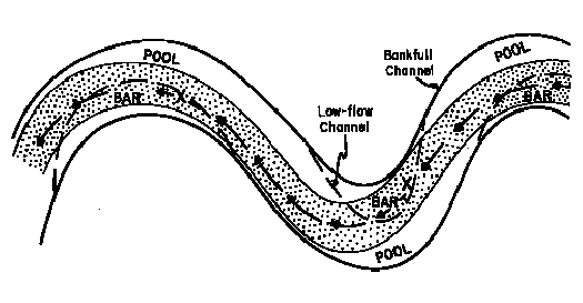
Figure 3. Schematic diagram of the path of most intense bedload transport
(shaded area) in relation to the bars and pools of river meanders.
The ability of a river to transport sediment of various sizes may change along the channel. An index of this transporting ability may be obtained from the computed total boundary shear stress, or average intensity of fluid drag per unit area of the bed. This measure is obtained from the product of the specific weight of water, the flow depth and the water surface slope. In most rivers there is a general increase in flow depth as discharge increases downstream, and a less regular decrease in gradient. In western Washington, the transition from mountains to lowlands imposes on the river a particularly sharp decrease in gradient and shear stress, although the change is not necessarily monotonic, as shown by the example in Figure 4. The downstream decrease in the river's ability to transport sediment leads to deposition in the reaches of sharpest decline. The larger particles are deposited in the upstream reaches of higher shear stress, while finer gravel and sand are carried downstream until they encounter a zone in which they can no longer be transported. This selective transport and sorting of bedload usually causes a general downstream decrease in the size of particles deposited on the channel bed and bars, as indicated in Figures 4a and 5. Such graphs are a useful part of any reconnaissance for gravel, because they allow one to choose reaches with the most favorable particle-size distribution for gravel mining or other uses.
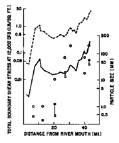
Figure 4a. Variation of total boundary shear stress (dashed line),
maximum particle size that can be transported (solid line),
and maximum (circles) and median (squares) particle size
found on channel bars along the Green River, Washington,
at a discharge of 12,000 cfs.
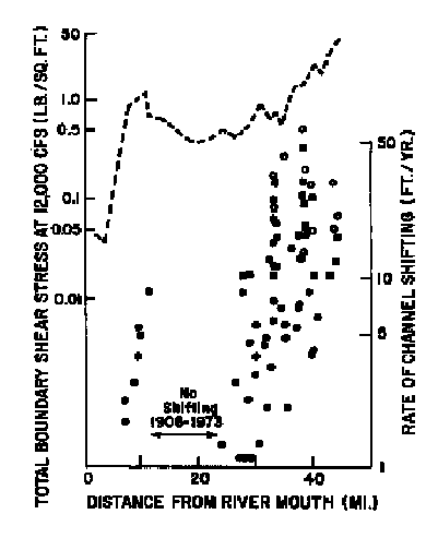
Figure 4b. Variation of total boundary shear stress (dashed lines),
and rates of lateral channel shifting during the periods
1893-1973 (solid circles), 1943-1973 (open circles), and
1968-1978 (solid squares).
A second result of changes in shear stress along a stream can be observed along reaches of the Green River where the river's ability to transport sediment declines most rapidly. Figure 4a indicates that in two reaches: between the Green River Gorge (River Mile 42) and Auburn (River Mile 28) and between the Black River (River Mile 10) and the Duwamish estuary sharp decreases in gradient cause a sharp drop in the size of particles on the channel bars. Each of these zones is also characterized by net accumulation of sediment, rapid bar formation and relatively intense channel shifting (Figure 4b). Such a reach offers the best opportunities for gravel harvesting without diminishing the size of gravel bars.
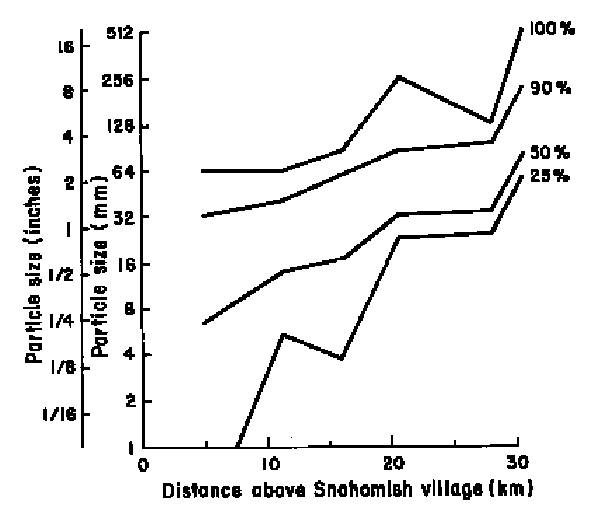
Figure 5. Downstream decrease of particle size on channel bars along
the Skykomish-Snohomish River. Each line indicates a percentile
on the grain-size distribution curve. Thus for a channel bar
at any distance along the river, one can read the particle
size which exceeds 25, 50, 90 and 100% of all gravel on the bar.
A similar zone of net gravel accumulation occurs in the Skykomish River immediately above its confluence with the Snoqualmie. In this case the lower Skykomish River and the Snohomish River below the confluence do not exert sufficient shear stress on the channel bed to transport the gravel bedload supplied by the steeper upstream reach of the Skykomish. A small amount of coarse sand and fine gravel, some of it suspended load while in the Skykomish, settles out as bedload in the Snohomish River and constitutes the gravel bars there. The bedload of the Snoqualmie River, which consists of fine and medium sand immediately above the confluence, becomes suspended load in the deeper and steeper Snohomish channel. When assessing the potential for gravel mining in channels or the possibility of some disturbance of a fluvial sediment transport system, it is often necessary to recognized such interdependencies. For example, if one were to assign gravel harvesting permits for neighboring bars in the Skykomish River it would be necessary to consider that the harvesting operations would be competitive in the sense of exploiting the same resource, namely the bedload of the Skykomish. However, bar scalping in the Snohomish River below the confluence would involve only the coarsest fraction of the suspended load from the Skykomish and a small proportion of its finer bedload. Hence, there would be little competition between a scalping operation on the lower Skykomish and the upper Snohomish reaches.
ESTIMATING THE RESOURCE
At present only rough estimates can be made of the harvestable volume of sand and gravel in western Washington. Different concepts and procedures are necessary for estimating the harvestable volume in each type of source. Meltwater channel deposits, kames, deltas, and recent alluvium have fixed volumes that are not being replenished. Their exploitation constitutes mining, whereas channel bar deposits are replenished intermittently by floods. In the latter case, estimation of the resource involves determining the rate at which sand and gravel can be removed without unacceptable damage to some other stream value such as fisheries or recreation.
Static Sources
The locations of many large static sand and gravel bodies (meltwater
channel deposits, kames deltas, and recent alluvium) in western
Washington are known approximately. Some of these are accessible
enough to be used in the near future as existing sources become
overtaxed. However, some of the deposits are also attractive sites
for urban development. They constitute flat, well-drained building
sites with spectacular views and are thus likely to be zoned for
residential use, which conflicts with mining activities. Some of the
largest sand-and-gravel resources could be preserved for mining if
they were zoned for that purpose. This can only be done if government
authorities are sure of the volume and quality of the resource and
that its exploitation will not conflict with other planning goals.
Present estimates involve only educated guesses about volumes in a
few areas (e.g. 2) and there has been little or no assessment of the
internal constitution, size distribution, and durability of the
deposits, or of the engineering, ecological , esthetic, and
transportation-related aspects of their exploitation. Hence the need
for a program, under the auspices of an agency such as the Washington
State Division of Geology and Earth Resources, to evaluate gravel
resources quantitatively.
Such a program would involve detailed mapping of the local surficial
geology with the particular aim of precisely defining the boundaries
of large sand and gravel bodies. Each important deposit should be
examined in detail so that the depth of overburden and the thickness
of unsuitable silty layers can be established and taken into
consideration in analyzing tonnage and the economics of exploitation.
For some deposits a program of drilling would be necessary to measure
the depth of the deposits and to obtain samples from throughout the
deposit for analysis of particle-size distribution and durability.
Such a program requires substantial investment of funds and the
involvement of some well-trained, critical field geologists, but it
would assure western Washington of adequate gravel supplies for the
foreseeable future.
In the absence of such a program, sand and gravel sources in western Washington can be only crudely estimated. Kroft (2) compiled an approximate list of glacial outwash deltas in western King County. He estimated the volume of available (i.e. not urbanized) delta deposits at 1.25 billion cubic yards, of which at least 22% (the data are not exactly consistent) have already been exploited. The largest remaining sources lie in the Snoqualmie Valley. An additional 890 million cubic yards were estimated to exist in meltwater channel deposits (Figure 6), two-thirds of which are in the Covington channel. Approximately another billion cubic yards of recent alluvium lie within 20 feet of the surface, mainly in the Snoqualmie Valley, but these deposits are highly variable and silty. Coarser material is available in the Skykomish Valley.
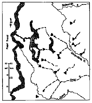
Figure 6. Distribution of glacial deltas (triangles), and major meltwater
channel deposits (dashed arrows) in King County. Based on a
map by Kroft (3) and our field observations.
River Channel Bars
The channel bars along some reaches of large rivers in western
Washington constitute a renewable resource of sand and gravel which
can be harvested without significant damage to the channel if
proper care is taken. However, the maximum annual harvest that
can be taken without significant alteration of the channel is small
relative to that available from the static sources described above.
The bars are a desirable source because they often lie close to the
market in the middle reaches of rivers; they consist dominantly of
the most useful sizes from medium sand up to 3 inches in diameter;
and because most of the mechanically weak lithologies have been
broken down and transported far downstream as suspended load. Thus
the river gravels tend to be "cleaner" and harder than the
mixture of sediment that enters the stream, or than some Pleistocene
deposits that have been weathered.
Estimation of the harvestable amount of sand and gravel from a river
channel is a complex problem, which cannot be adequately solved at
this time for western Washington rivers. However, by an approximate
analysis it is possible to outline the constraints on harvesting and
the data needed for refining estimates.
It is necessary to know first how much sand and gravel is being
transported across the channel bars at a particular river cross
section, and second how much of the bar material can be removed each
year without disrupting the sediment transport system enough to
diminish the area of spawning gravel, or to cause channel instability
or other undesirable effects. These two quantities are not equal.
Channel bars are temporary storage sites through which sand and
gravel pass. Most bars are in approximate equilibrium, so that the
influx and downstream transport of material are equal when averaged
over a number of years. If all of the sand and gravel reaching such a
bar is removed, the supply to bars downstream will diminish. Since
sand and gravel will continue to be transported from these downstream
bars by the river, their size will decrease. Other bars, in certain
recognizable reaches of the river, constitute the points of final
deposition (on a human time scale) for gravel, while the sand
fraction may be carried further downstream. The most favorable places
for finding rapidly accumulating gravel deposits are reaches with
rapidly declining shear stress, such as that between river miles 42
and 34 in Figure 4. In such zones it is common to find rapid
evolution of point bars, and mid-channel bars, intense channel
shifting (Figure 4b) or avulsion, and frequent burial of vegetation
and other floodplain features.
We will deal first with techniques for estimating the flux of coarse
sediment across a channel bar and later with the problem of
estimating the volume that can be harvested without diminishing other
gravel bars in the vicinity. We will illustrate the problem with an
example for the Snohomish River system (4). Unfortunately,
theoretical equations for computing bedload transport rate do not
work well in the coarse-bedded rivers of the Pacific Northwest. These
formulae are based on the assumption that the factor controlling
sediment transport is the river's capacity for transport, and
therefore the gradient and depth of velocity. In thickly-vegetated
catchments the influx of sediment from the drainage basin is usually
less than the river's capacity for transport, so that influx rate
limits channel sediment transport. Thus, our attempts to apply the
Einstein (5) and Leopold-Emmett (6) methods yielded bedload rates
many times greater than measured values (see later).
Rates of bedload transport have been measured at only one site in the
Snohomish River basin: on the main channel near Snohomish village
(7). The bedload measurements were collected by personnel of the U.S.
Geological Survey, using a Helley-Smith bedload sampler (8). Only
nine measurements were made, but they sampled the high range of flows
(including the major flood of December, 1975) that transport most of
the river's bedload. We have used these scanty data to construct a
bedload rating curve, shown in Figure 7. The regression line is not
well-defined, but it indicates that only a few hundred to a few
thousand tons per day are transported along the bed. Such
measurements could be augmented and extended to other sites on the
river system relatively easily. We used this rating curve in
combination with 10 years of daily flow records (1967-1977) from the
U.S. Geological Survey to calculate the average annual rate of
bedload transport past the site. The average was 26,000 tons/yr or
15,000 yd3/yr (9), but varied strongly between years.
Bedload measurements are not made routinely on most rivers. In
depositional zones of some rivers, repeated surveys of channel
cross-sections allows the computation of long-term average rates of
accumulation (10), but such measurements are rare, and must be
carried out over many years to yield useful averages. In the absence
of methods for direct assessment of bedload, one must resort to very
rough, indirect methods using the yields of suspended load.
Bedload typically constitutes only a small fraction of the total load of most rivers; suspended load is usually the dominant component. A survey of published values of the ratio between annual bedload and annual total load for rivers in various parts of the world (11, 12) indicates an average proportion of 3.5 - 5 percent for lowland rivers and of 10 percent for hilly to mountainous basins. Thus, if the bedload contribution is symbolized by Y(%), one can write
Annual bedload transport = (Y/(100-Y)) x Annual suspended load transport
It should be emphasized that such a computation is very rough, and
that even the suspended load transport is rarely known to within 10%.
Nevertheless, the technique should yield the correct order of
magnitude for the bedload yield, and it can be checked by other
procedures referred to in this paper.
The annual suspended sediment transport in the Snohomish River was estimated from U.S. Geological Survey (7) measurements, shown in Figure 7, and daily flow records (also from the USGS) for the decade 1967-1977. The computed yield was 501,000 tons/year. The Snohomish River just below the Skykomish-Snoqualmie confluence is a lowland river but its bedload is strongly affected by the settling out of suspended load from the steeper Skykomish River. Therefore, a value of Y on the upper end of the range for lowland rivers seems appropriate. If Y = 5% is inserted into the equation above, one obtains a bedload yield of 26,000 tons/yr (15,000 yd3/yr). The exact agreement with the preceding calculation of bedload is fortuitous, but suggests that the indirect method should give approximately correct values.
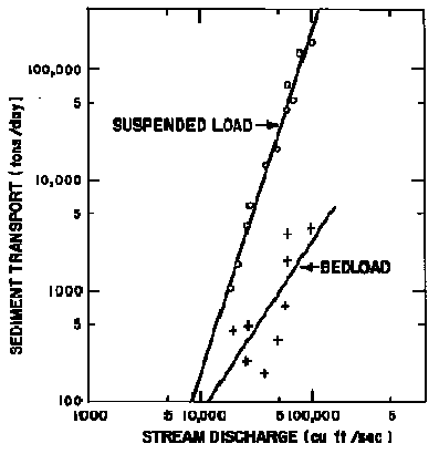
Figure 7 Suspended load and bedload rating curves for the
Snohomish River at Snohomish village. Based on
Geological Survey measurements in (7).
We have made similar computations for other stations in the Snohomish
basin, using the suspended sediment data of Nelson (13). Differences
between bedload yields at various stations agree with our qualitative
observations of the pattern of sediment accumulation along the river
channels (4).
Even more indirect values for bedload transport rates can be obtained
through compilation of suspended sediment yields from basins
throughout the region. These data are obtainable from various U.S.
Geological Survey publications and files and from a few journal
articles. Within a region of relatively homogeneous physiography,
climate, vegetation, and land use, it can be expected that basin
sediment yields will cluster within certain definable limits. For
example, Nelson's (13) data show that almost all of the annual
sediment yields in the Snohomish basin lie between 100 and 700
tons/mi2 of basin area, while other USGS file data indicate similar
yields in other basins on the west side of the Cascades, yields of
10-100 tons/mi2/yr in the upper Columbia basin, and 500-5,000
tons/mi2/yr in the Coast Ranges of California. These are broad ranges
to be sure, but in combination with the finding from many other
regions that average annual bedload yields are generally of the order
of a few percent of total yield, these values can be used to estimate
the order of magnitude of the bedload supply. For example, one can
state with some confidence that a site on the Skvkomish River which
receives drainage from 300 sq. mi should have a bedload transport
between 5000 and 20,000 tons/yr. These are wide limits, but the point
is clear that the supply is small by comparison with the industrial
demands for gravel in western Washington. Although the big rivers
produce desirable gravel, they can supply only a small fraction of
the market demand, and because the supply varies with flow conditions
it will be exceedingly small in some years. The only way to refine
these estimates at present is to initiate a program of bedload
transport measurements by the methods referred to above, and to
refine the application of theoretical computations on the basis of
these measurements so that interpolations can be made between
sampling sites.
Figure 3 indicates that not all of the bedload transport occurs over
the portion of a bar that emerges from the water and can be scalped
in summer. Harvesting of all or most of the bedload passing a site
would interrupt the supply to downstream bars and diminish or even
eliminate them. Channel banks would be undermined in new locations,
the river could shift unpredictably, and damage would probably occur
to structures and to spawning areas. For this reason, gravel
harvesting should be conducted in such a way that a considerable
fraction of the bedload arriving at a site is allowed to pass on to
downstream bars.
Unfortunately, no method exists for computing how much sediment
should be allowed to pass downstream to maintain the channel bars.
The problem can only be addressed empirically at present by observing
channel changes that result from various rates of gravel extraction.
The best record of channel changes is usually that from aerial
photographs. For example, we obtained air photos of gravel bars in
the Skykomish and Snohomish Rivers taken in 1948, 1961, 1969 and
1976. Changes in bar area could be measured on the photographs (after
adjusting for the effects of differences in water elevation), and
changes in bar elevation could be estimated with the parallel bar
accessory to a mirror stereoscope. Records of gravel extraction from
various bars indicated that the average extraction rates for the
periods between photographs had ranged from zero to 84,000 tons/year.
For example, one bar in a six-mile zone, for which differences in
sediment yields had indicated the accumulation of between 5,000 and
21,000 yd3/yr, grew by 3,000 yd3/yr between 1948 and 1961 in the
absence of gravel harvesting. Between 1961 and 1968, an average
extraction rate of 50,000 yd3/yr decimated the bar, and slightly
diminished the adjacent bars upstream and downstream. During the
period 1969-1976, when the extraction rate declined to an average of
15,000 yd3/yr, no significant changes were observed.
Although these observations are complicated by the vagaries of flow
and sediment transport as well as by vague records of extraction,
they suggest that 10,000 to 15,000 yd3/yr could be removed from this
bar or one of its neighbors without causing a long-term erosive
trend. Such a harvest could not be taken from more than one bar,
although the total harvest could be divided between several sites. A
reasonable policy in such a case would be to limit extraction in the
reach to perhaps 12,000 yd3/yr and to monitor the results over a
number of years, either by ground survey or photographically. If
there are no unfavorable effects, the limit could be cautiously
raised. However, doubling of the offtake would remove more gravel
than enters the reach, and could not be maintained for long. Other
case studies are reported elsewhere (4).
In some channel reaches, extraction limits need to be set in the absence of either aerial photographs or of earlier extraction records. In such cases, a reasonable initial policy might be to limit total offtake from the bars in a reach to one half of the estimated annual bedflow influx. The resulting channel behavior can be monitored and the limit decreased or raised cautiously if appropriate. Where sequences of aerial photographs show that the bars are diminishing even in the absence of gravel extraction, harvesting is not likely to be a wise policy.
ENVIRONMENTAL IMPACTS OF GRAVEL EXTRACTION
Exploitation of the various gravel sources referred to in this paper could have deleterious consequences that could be minimized with foresight and an understanding of the geomorphic basis of the hazard.
Pleistocene Meltwater Deposits
The most frequent consequence of exploiting these highly visible features is the creation of an obvious scar in the landscape. Also, during their active lives the quarries are unsightly, dusty, and noisy. These problems could be reduced by designing the quarry to reduce its visibility, and by regrading and revegetating the site after its exhaustion. Removal of vegetation and disturbance of slopes and dirt roads by heavy vehicles can generate an important local source of sediment that erodes into nearby streams and ditches. Various sediment control techniques, such as installation of settling ponds or design of the work to prevent the concentration of runoff, can be used to alleviate this problem. Some meltwater deposits are aquifers, and they may consist of gravel that is too coarse to filter contaminants from water. In such cases it is prudent to ensure that oil, fuel or other pollutants do not enter the groundwater either during or after quarry operation. This is a particularly important issue where the aquifers are shallow and close to streams.
Recent Alluvium
Floodplains and low terraces in western Washington are often
cultivated or used for dairy farming. To an increasing extent they
will probably also be used for parks and other facilities associated
with recreation on the major rivers. The esthetic degradation
associated with gravel mining on valley floors conflicts with these
uses to some extent, although the conflict could be limited through
careful site planning and regrading after gravel extraction. Some of
the present eyesores associated with gravel mining could easily be
avoided by greater sensitivity to esthetic values on the part of landowners.
Gravel extraction creates large, deep pits, the floors of which lie
below flood levels in the river. The pits are usually diked to
prevent invasion by the river during overbank flooding, but the dike
material is commonly obtained from the pit and therefore is of a size
that can be eroded by the river. Dike collapse and river inflow
allows entrapment of fish, and in some cases may cause drastic
channel displacement, erosion of new channels across the floodplain,
and undermining of hillslopes, bridges, and other structures. The
channel-diversion hazard is particularly great if gravel extraction
is carried out in or near former flood channels crossing point bars
in the most recently deposited portion of a floodplain.
The threat of river channel diversion is illustrated in Figure 8. Recent alluvium of the Yakima River at Union Gap, Washington, had been mined from deep pits in the valley floor. Each pit was diked, but lateral channel shifting undermined the dike of the upper gravel pit during a modest flood in 1971. The river entered this pit and flowed out of the downstream end of the pit, across the floodplain, and into a second gravel pit 4,000 feet downstream. There it breached another dike and re-entered the original main channel. This avulsion moved the channel up to 2000-3000 feet westward in a single flood, causing it to begin undermining the embankment of an interstate highway. The consequences do not end with the initial diversion because the new channel is shorter, steeper, and less sinuous than the original channel. Because the sinuosity of the main channel had not changed during the preceding 34 years for which there is an air-photo record, one might expect the river in the diverted reach to re-establish a more sinuous course by bar disposition, bank erosion, and rapid lateral shifting.
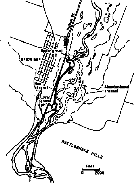
Figure 8. Channel diversion across the Yakima River floodplain at
Union Gap, WA, caused by dike failure in a gravel pit. Tributaries
to the river are represented by dashes separated by dots.
The presence of many abandoned gravel pits in the floodplains of the Yakima, Stillaguamish, and other rivers increases the chances of future diversions of this kind. Fortunately, sequences of maps and air-photos can be used in combination with field observations of floodplain microtopography and stratigraphy to predict whether a proposed or active gravel pit is likely to be invaded, as well as the course of events after breaching (4).
Channel Bars
Ill-planned and careless harvesting of sand and gravel from river
channel bars can have serious impacts on stream turbidity, bar
stability, channel evolution, and various other subtle aspects of
river behavior. There may also be impacts on fish habitat, esthetics,
and other river values as an indirect result of the channel disturbance.
Some of the impacts on water quality are now controlled by law. Extraction
should not be conducted below the water level in order to keep
turbidity levels to a minimum, and settling ponds must be used to
detain gravel-washing water long enough for settling out of fine
particles. A more difficult problem to control is the leakage of oil
from machinery into the stream.
The most obvious impact of gravel harvest is likely to be a reduction
in the size of the gravel bar if the rate of extraction exceeds the
difference between the rate of sediment influx and the rate at which
sediment is transported downstream to the next bar. As a result, the
volume of the gravel bar is reduced and in extreme cases the course
of the river may be altered. Our air-photo analysis of channel
changes during several years of intense gravel harvesting on the
Skykomish and Stillaguamish Rivers (4) indicates that mining of a
point bar often leads to disturbance of the next bar upstream.
Lowering of the bar surface by two or three feet is small in
comparison with the amplitude of depth variations between
regularly-spaced pools and riffles along most large channels, and the
disturbance caused by gravel mining usually does not propagate more
than one bar upstream.
Downstream effects of bar scalping are much larger and potentially
more serious. Between 1961 and 1969 removal of gravel from a
Skykomish River bar at rates several times the replenishment rate
decreased not only the size of the exploited bar, but of several bars
as much as 2.5 miles downstream. However, in most cases along the
Snohomish and Stillaguamish channels, where the extraction rate is
closer to the supply rate, the downstream effect extends only one or
two bars downstream from the extraction site.
The diminution of channel bars can have a variety of consequences for
channel stability and, unfortunately, theoretical predictions are
complex and require large amounts of hydraulic data that are not
routinely available for gravel extraction sites. Thus, it is usually
necessary to rely on qualitative or rough quantitative
interpretations of channel behavior at a site and of the probable
consequences of bar reduction on the mode and rate of channel
shifting, the stability of flood dikes and streamside property, fish
habitat, and recreational amenities. One of the most useful methods
for such interpretation is the comparison of channel position and
morphology on sequences of aerial photographs, and interpretation
based on an understanding of flow and sediment transport in rivers.
Study of the past behavior of a channel bend or a braided channel
reach during periods of heavy, light, and moderate gravel harvesting
can yield results which are applicable to that site in the future
and, with appropriate care, to similar reaches in the same river
system or region.
In some cases, such an analysis may suggest that the extraction of
gravel from a point bar of a mid-channel bar would have a stabilizing
effect on the channel. For example, the accumulation of sand and
gravel on a point bar tends to force the main thread of the current
towards the opposite bank, where this high-velocity core of the flow
concentrates high shear stress on the concave bank. The resulting
undermining of the outer bank, together with continued deposition on
the point bar, causes the channel to shift laterally across its
floodplain. In the sediment-accumulating reaches of the large rivers
in western Washington, average channel-shifting rates of up to 10-20
ft/yr are not uncommon and can pose a threat to bridges, houses,
roads, and farmland. Careful scalping of the annual accumulation of
sediment from the point bar may be useful in stabilizing such channels.
On the other hand, if a point bar is lowered too much by excessive
harvesting, a destabilizing effect may come about. As the bar is
lowered, a greater proportion of high flows follows a more direct
path downstream, rather than being diverted to the longer path around
the bend. The shorter path increases the water-surface slope across
the bar with an increase in boundary shear stress over the downstream
end of the point bar. There is a likelihood of scouring and breaching
of the point bar so that the bend may be cut off as the water
gradually forms a new channel, particularly if harvesting operations
or access roads cause any diversion or concentration of flow. If such
a cut-off occurs, a complicated sequence of events is likely to ensue
which is difficult to predict in detail. The channel realignment is
usually accompanied by abandonment of the loop through the pool, and
by considerable local re-distribution of sediment as a result of bank
erosion and the initiation of new point bars as the river re-establishes
its original sinuosity. The changes would be most dramatic over a
distance of one or two bends downstream of the cut-off.
On the basis of an understanding of fluvial geomorphology it is
possible to develop a methodology for managing gravel extraction from
bars to minimize channel disturbance. We suggest that such a
methodology include the following steps which should be taken before
a gravel mining permit is granted:
(1) Analyze the recent history of channel reach, with particular
emphasis on modes and rates of point-bar formation and channel
shifting. Sequences of aerial photographs and maps can be used for
this purpose, and the earlier channel positions superimposed on the
most recent map. The task is easily and rapidly accomplished through
the use of a mirror stereoscope or a zoom-transfer stereoscope.
Observations of bar sediments and vegetation on the air photos and in
the field provide further insights into past river behavior and
probable future evolution.
(2) Estimate how much bedload is moving past the site and
accumulating on a bar or in a channel reach. Records of sediment
transport provide a starting point, as indicated above, and air-photo
interpretation of changes in bar form allow some extraction limits to
be cautiously imposed. For example, we suggest the following
guidelines be tried on an experimental basis. If the gravel bars in a
reach are diminishing, withhold permits. If the bars are stable or
growing, limit harvest rates to one-half of the estimated bedload
transport rate. If several applicants are competing for gravel on
point bars along a reach, divide the harvestable volume between them.
Monitor the channel by ground survey or through the regular aerial
photography that is flown in most regions, and renew permits every
five years. At that time, the extraction limits can be altered to
reflect channel changes that have occurred during the permit period.
Our suggestions should be refined as more systematic observations
become available, and in the light of legal requirements, but we
offer them here to stimulate discussion.
(3) Estimate the probable impact of bar scalping on the form of
adjacent bars. This can be done in an approximate fashion by
examining airphoto records of the effects of previous gravel mining
on neighboring bars along similar reaches of the same river. Limit
extraction rates to values below those that have caused undesirable
consequences in similar situations.
(4) Require the applicant to provide details of the mining operation, including the location of access roads and scalping, the alignment of trenches, and the disposition of pollutants. The applicant could also be furnished with advice on how to minimize the possibility of cutoffs and channel diversions, on the alignment of trenches transverse to the flow to trap bedload more efficiently, and on avoidance of lowlying abandoned channels or sloughs on the floodplain.
SUMMARY
Glacial deposits, floodplain alluvium and active river channel sediment are sources of gravel in western Washington. The importance of individual gravel sources can be defined by location and accessibility, harvestable volume, size distribution, and structural and chemical strength of the material. Due to distribution of bedrock types and the past activity of glaciers, the Puget Sound area has an abundance of gravel deposits, and most gravel currently mined is from ancient deposits rather than present stream channels. Some gravel is harvested from most of the large rivers draining into the Sound but outside the Puget Sound area, river channel sediments are a principal source of gravel. However, these gravels are often derived from the mechanically weak rock types which underlie the surrounding hills. When used to surface roads, these gravels break down and contribute much fine sediment to adjacent stream channels. The total available gravel supply in western Washington is only approximately known and the environmental consequences of mining operations are not well established.
Pressure for use of gravel in accessible, ecologically sensitive, and
potentially unstable river channels should be assessed in terms of
full knowledge of availability of gravel in glacial deposits and
valley floor alluvium in western Washington. Along specific sections
of river systems where long-term deposition of gravel is occurring,
gravel in bars can be harvested as a renewable resource without
causing significant downstream or upstream channel instability. These
sections of river channels may be recognized in the field by the
presence of rapidly migrating river bends, rapidly declining channel
gradient, abundant, algae-free gravel in bars, and island bars. These
signs can be quantitatively defined from sequential aerial
photographs over a period of years. Confirmation that there should be
long-term gravel deposition can be made from simple hydraulic
calculations which evaluate the rate of change in the transporting
capability of the river through the section of interests. Finally
quantitative estimates can be made from direct measurements of gravel
transport rates and from published records of suspended load
transport rates. Until more is known, as a minimum standard the
harvestable volume should not exceed one-half the estimated bedload
transport through those reaches showing geomorphic signs of active
gravel deposition. Long-term monitoring of extraction rates, sediment
transport rates, and channel stability upstream and downstream of
gravel borrow area would improve this estimate. The mining of each of
the three sources of gravel in Washington have predictable
environmental consequences of a nonbiologic nature which can be
avoided with proper planning. Removal of glacial deposits may destroy
or contaminate ground water supply to neighboring wells. Mining of
valley-floor alluvium and inadequate diking of pit walls may cause
catastrophic diversion of the channel. Excessive removal of gravel
from bars in rivers may lead to channel diversion and reduction of
upstream and downstream gravel bars. Periodic field checking of river
gravel harvesting sites and recording total extraction could prevent
long-term degradation of channels by controlling the extraction rates
to non-destructive levels.
Before a gravel mining permit is issued at least four steps should be followed: (1) define historical activity of a river at proposed site; (2) estimate bedload transport rate through reach; (3) evaluate probable impact of bar scalping on channel stability and (4) require explicit information on proposed mining procedure.
REFERENCES
|
1. |
Kadomura, H.,1980. Erosion by human activities in Japan., GeoJournal. 4:133-144. |
|
2. |
Kroft, D.J. 1972. Sand and gravel deposits in western King County, Washington. M.S. Thesis, University of Washington, 62 pp. |
|
3. |
Leighton, M.M. 1919. The roadbuilding sands and gravels of Washington. Washington Geological Survey Bull.22, 307 p. |
|
4. |
Dunne, T. 1979. Sediment transport and gravel resources in the Snohomish River Basin. Report to Snohomish County Physical Planning Office, 97 pp. |
|
5. |
Einstein, H.A. 1950. The bedload function for sediment transport in open channel flow. U.S. Dept. of Agric. Tech. Bull. 1026. |
|
6. |
Leopold, L.B. and Emmett, W.W. 1976. Bedload measurements, East Fork River, Wyoming. Proc. Nat. Acad. Sci., 73:1000-1004. |
|
7. |
U.S. Geological Survey. 1975. Water-Data Report WA-75-1. Water Resources Div., Tacoma, WA. |
|
8. |
Emmett, W.W. 1980. A field calibration of the sediment-trapping characteristics of the Helley-Smith bedload sampler. U.S. Geological Survey Professional Paper 1139. |
|
9. |
Geiger, A.F. 1965. Developing sediment storage requirements for upstream retarding structures. Proc. Federal Inter-agency Sed. Conf., U.S. Dept. Agric. Misc. Pub. 970:881-885. |
|
10. |
Griffiths, G.A. 1979. Recent sedimentation history of the Waimakariri River, New Zealand. J. Hydrol. (NZ) 18:6-28. |
|
11. |
Gregory, K.J. and Walling, D.E. 1973. Drainage basin form and process. Halsted Press, NY. 456 pp. |
|
12. |
Maddock, T. 1976. In: Sedimentation Engineering, (ed. V.A. Vanoni). Amer. Soc. Civil Engrs. NY. 745 pp. |
|
13. |
Nelson, L.M. 1971. Sediment transport by streams in the Snohomish River Basin, Washington, October 1967-June 1969. U.S. Geol. Survey Open-file Rept. |
|
14. |
Dunne, T., Dietrich, W.E., and Nimick, D. 1976. The Yakima River between the Selah and Union Gaps. In: The Yakima River Regional Greenway. Report by Jones and Jones, Inc., to City of Yakima: A-1 to A-25. |
|
15. |
McKee, E.B. 1972. Cascadia. McGraw-Hill, NY. 394 pp. |